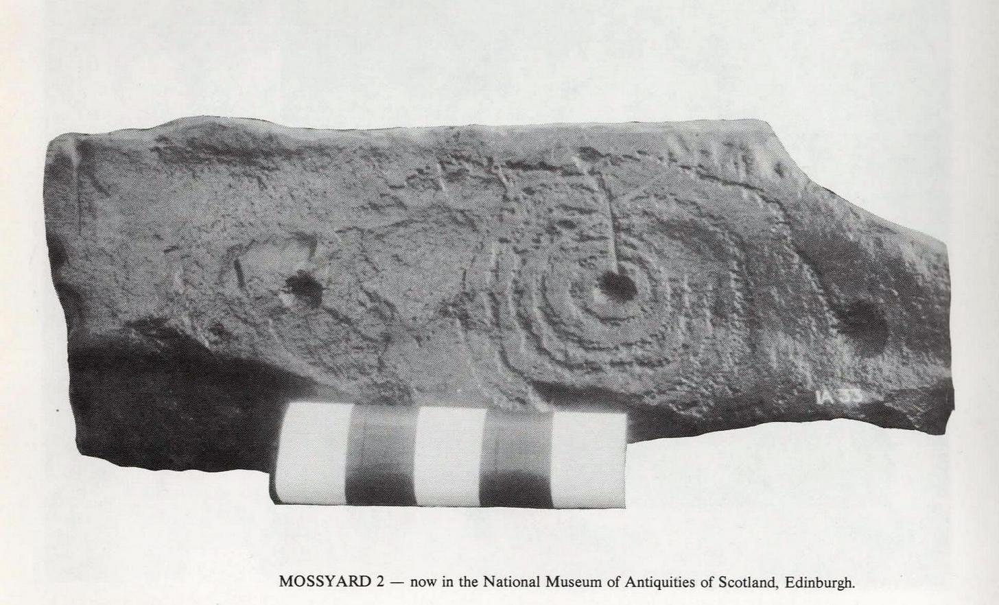
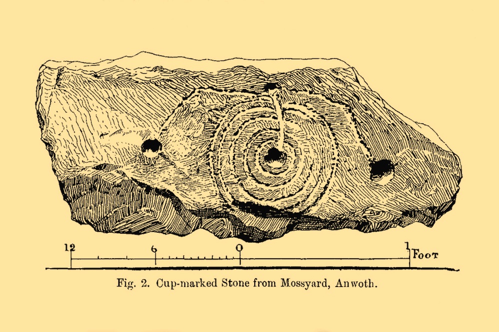
Cup-and-Ring Stone (removed): OS Grid Reference – NX 550 520
Archaeology & History
This impressive-looking carving was brought to the attention of the Scottish Society of Antiquaries by Sir Herbert H. Maxwell (1900), who thereafter moved it to the National Museum where, I presume, it still lives, in a box somewhere, sleeping gently. Maxwell’s brief resumé of the stone was as follows:
“Cup and Ring-marked Slab…found in a dyke on the farm of Mossyard, Anwoth, Kirkcudbrightshire. This cup-and ring-sculpturing is peculiar in having five rings round the central cup crossed by a gutter which ends in another cup from which gutters also proceed to right and left, each terminating in a cup.”
In Ron Morris’s (1979) survey he erroneously told how the carving had been found in a wall instead of the dyke from whence it came; but, that triviality aside, he described it as,
Morris’ 1979 photoMaxwell’s 1900 drawing
“A cup-and-five-rings, the rings slightly flattened where a radial groove from the cup passes through them. 23cm (9½in) diameter, grooves connecting this with 3 other cups. Carving depths up to ½cm (¼in). The rings are rather lightly pecked though quite wide and well preserved. All gapped, except the inner ring.”
If anyone is able to get any good photos of the carving, out from its museum hideaway, it would be good to see how it’s coping therein….
References:
Maxwell, Herbert R., “Donations to the Museum and Library,” in Proceedings Society Antiquaries, Scotland, volume 35, 1901.
Morris, Ronald W.B., The Prehistoric Rock Art of Galloway and the Isle of Man, Blandford: Poole 1979.
Cup-and-Ring Stone (removed): OS Grid Reference – NX 546 530
Archaeology & History
A.E. Truckell’s 1961 photo (TGDNHAS, 1961)
A small multiple-ringed archetypal design consisting of a central cup-mark with seven consecutive rings emerging from it, with a second outlying, incomplete cup-and-double-ring that nearly touches the outer edge of the seven-rings, was found by a Mr Sproat “in the bed of a shallow stream on Laggan farm” in 1960. The design, as the old photo (right) shows, is very well preserved, suggesting that it cannot have been in the stream for too long, as the erosion on the carving isn’t in anyway excessive. In all likelihood it originally came from a nearby prehistoric tomb: of which, there are several upstream from the farm.
Described by A.E. Truckell (1961) as “a particularly fine example”, the carving is on a particularly small and thin piece of stone, measuring 18 inch by 8 inch amd just 2 inches thick, with one edge of it snapped-off. It’s obviously no longer in situ and, I presume, is still resting somewhere in the Kirkcudbright museum.
References:
Morris, Ronald W.B., The Prehistoric Rock Art of Galloway and the Isle of Man, Blandford: Poole 1979.
Morris, Ronald W.B., “The Cup-and-Ring Marks and Similar Sculptures of South-West Scotland,” in Transactions of the Ancient Monuments Society, volume 14, 1967.
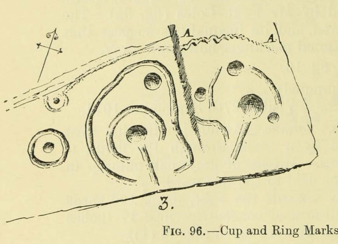
Cup-and-Ring Stone (lost): OS Grid Reference – NX 68700 44699
Archaeology & History
Coles’ 1895 sketch
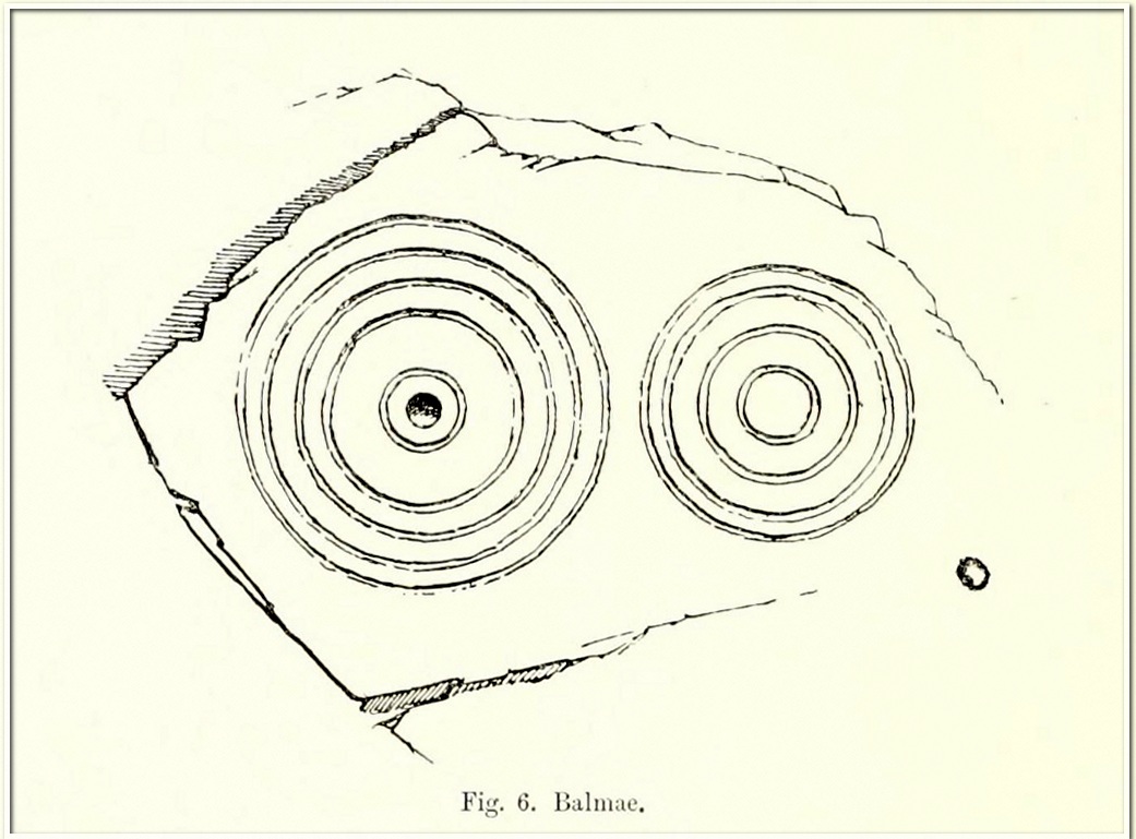
This impressive-looking carving was rediscovered in the 1880s during one of Fred Coles’ ventures uncovering many of the petroglyphs in this area. It could be found, he said, “some three hundred yards south-east of Balmae House.” When the local historian Malcolm Harper visited Samuel Fletcher who lived in the cottage at Balmae a few years after it had been discovered, he spoke enthusiastically about the carvings and knew much about them, but Harper doesn’t specifically mention whether or not he’d seen this stone (he probably did). Nowadays the carving is covered in thickets of gorse and and, as a result, it hasn’t been seen in many a year. The great Scottish petroglyph hunter Kaledon Naddair may have been one of the last people to visit it.
It’s impressive, as Mr Coles’ (1895) sketch shows, comprising, as he said, of
“two sets of concentric rings, one having four, the other five and a central cup. It is smooth, and slopes to the W. at an angle of 40°. The largest ring is 24 inches in diameter.”
A number of other impressive multiple-ringed carvings exist hereby that have also fallen prey to the cover of gorse. So get some hedge-cutters and decent gardening gloves if you’re gonna look for this one!
Morris, Ronald W.B., “The Cup-and-Ring Marks and Similar Sculptures of South-West Scotland,” in Transactions of the Ancient Monuments Society, volume 14, 1967.
Morris, Ronald W.B., The Prehistoric Rock Art of Galloway and the Isle of Man, Blandford: Poole 1979.
Royal Commission Ancient & Historical Monuments & Constructions of Scotland, Inventory of Monuments and Constructions in Galloway – volume 2: County of the Stewatry of Kirkcudbrightshire , HMSO: Edinburgh 1914.
Stone Circle (destroyed): OS Grid Reference – NX 681 450
Archaeology & History
In an area that’s littered with prehistoric rock art, this “stone circle” at Knockshinne—listed in Burl’s (2000) magnum opus—is a debatable entry that was described in one of Fred Coles’ (1895) many articles on such matters. When he came here he told how to the west,
“of Balmae House, and near the base of Knockshinnie, four stones in situ, all, I think, granite, and the sites of six others as distinctly observable…. A massive stone lies outside the circle on the south. Diameter 72 feet.”
Subsequent visits to the same spot by the Royal Commission (1914) gave a somewhat different interpretation to that suggested by Coles. They told us that,
“This setting of stones, noted elsewhere as a stone circle, lies on rough pasture some 100 yards below the road passing to the south-west of Knockshinnie, and about ¼ mile west-north-west of Balmae. It consists of four granite blocks, the highest standing about li feet above ground, placed on an arc with a chord of 76 feet and radius at centre of 21 feet. The stones are placed at irregular distances on a sloping bank, so that the lowest stone is at 8 feet lower elevation than the upper one. Other two displaced boulders and a number of smaller stones lie in a heap to the north-west, and the beds of stones which have been removed from the setting are visible. Though the boulders have been placed in position by man’s hand, it is doubtful if they have ever been part of a stone circle, and from their situation on a slope below a plateau it is probable that they represent the line of an old dyke.”
By the 1970s, all that remained here was a line of three stones, but these have subsequently been removed or destroyed. Modern archaeological interpretation goes against Burl (2000) and Coles, suggesting that the stones were more likely part of an ancient dyke.
References:
Burl, Aubrey, The Stone Circles of Britain, Ireland and Brittany, Yale University Press 2000.
Coles, Fred, “The stone circles of the Stewartry of Kirkcudbright”, in Proceedings Society Antiquaries, Scotland, volume 29, 1895.
Royal Commission Ancient & Historical Monuments & Constructions of Scotland, Inventory of Monuments and Constructions in Galloway – volume 2: County of the Stewatry of Kirkcudbrightshire , HMSO: Edinburgh 1914.
Acknowledgements:Huge thanks for use of the Ordnance Survey map in this site profile, reproduced with the kind permission of the National Library of Scotland.
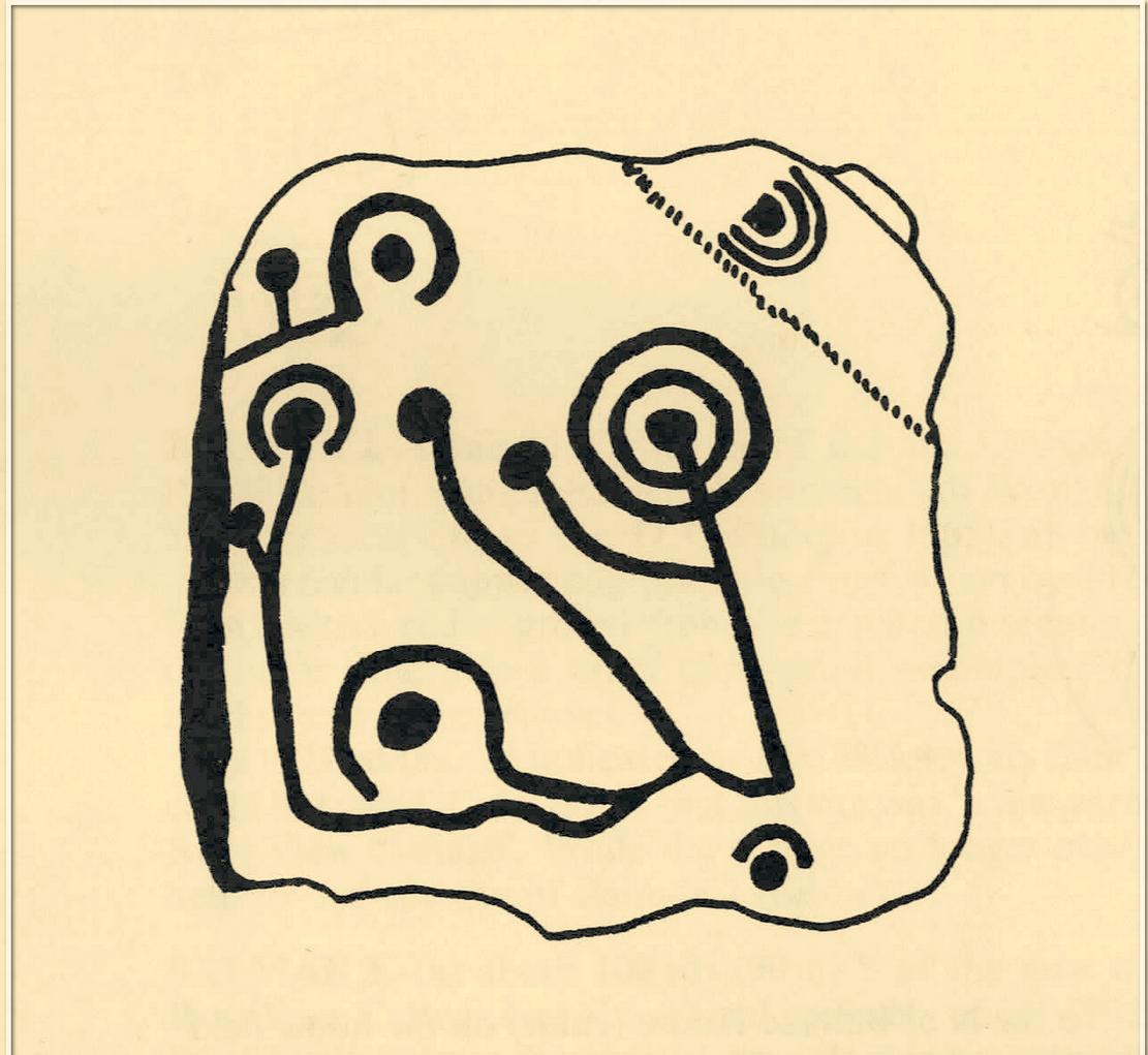
Cup-and-Ring Stone (lost): OS Grid Reference – NX 529 528
Also Known as:
Bardriston
Archaeology & History
In a region possessed with a good number of cup and ring stones, this one on the lower slopes of Barholm Hill may have once been part of a prehistoric tomb, or cist cover. A fairly decent design had been carved onto a small flat slab of stone which, when uncovered in the 19th century, doesn’t seem to have been in its original position. As the great Fred Coles (1894) told us:
Coles’ 1895 sketch
“The Bardristan slab…was removed from amongst the stones of an old drain in 1889, and, through Mr Kinna’s care, it is now preserved at Bardristan. The evident attempt to square the stone itself; the extreme smallness of the rings ; the direct connection of the grooves, in all cases but one, with cups; and lastly, the vivid sharpness of the whole sculpturing, in which the tool-work is clear much beyond the ordinary, all combine to render this Bardristan slab unusually interesting and valuable.”
Less than twenty years after Coles’ description, the Royal Commission (1914) lads visited the site hoping to make their own assessment, but the carving had already been lost. Referring to Coles’ account, they told how,
“inquiry there failed to elicit information concerning it, and it appears to have been lost. Mr Coles’ illustration…shows in the general intercommunication of the various cups a feature which characterises the stone at Kirkclaugh, about ¼ mile to the south of Bardriston.”
In the subsequent commentaries on this carving by Ron Morris (1967; 1979) and A.E. Truckell (1961), its whereabouts remained a mystery and, to this day, we know not what became of it…
Morris, Ronald W.B., “The Cup-and-Ring Marks and Similar Sculptures of South-West Scotland,” in Transactions of the Ancient Monuments Society, volume 14, 1967.
Morris, Ronald W.B., The Prehistoric Rock Art of Galloway and the Isle of Man, Blandford: Poole 1979.
Royal Commission Ancient & Historical Monuments & Constructions of Scotland, Inventory of Monuments and Constructions in Galloway – volume 2: County of the Stewatry of Kirkcudbrightshire , HMSO: Edinburgh 1914.
Truckell, A.E., “Cup-and-Ring-Marked Slabs in the Cairnholy and Auchinlarie Area,” in Transactions of Galloway & Dumfriesshire Natural History & Antiquarian Society, volume 40, 1961.
Acknowledgements:Huge thanks for use of the Ordnance Survey map in this site profile, reproduced with the kind permission of the National Library of Scotland.
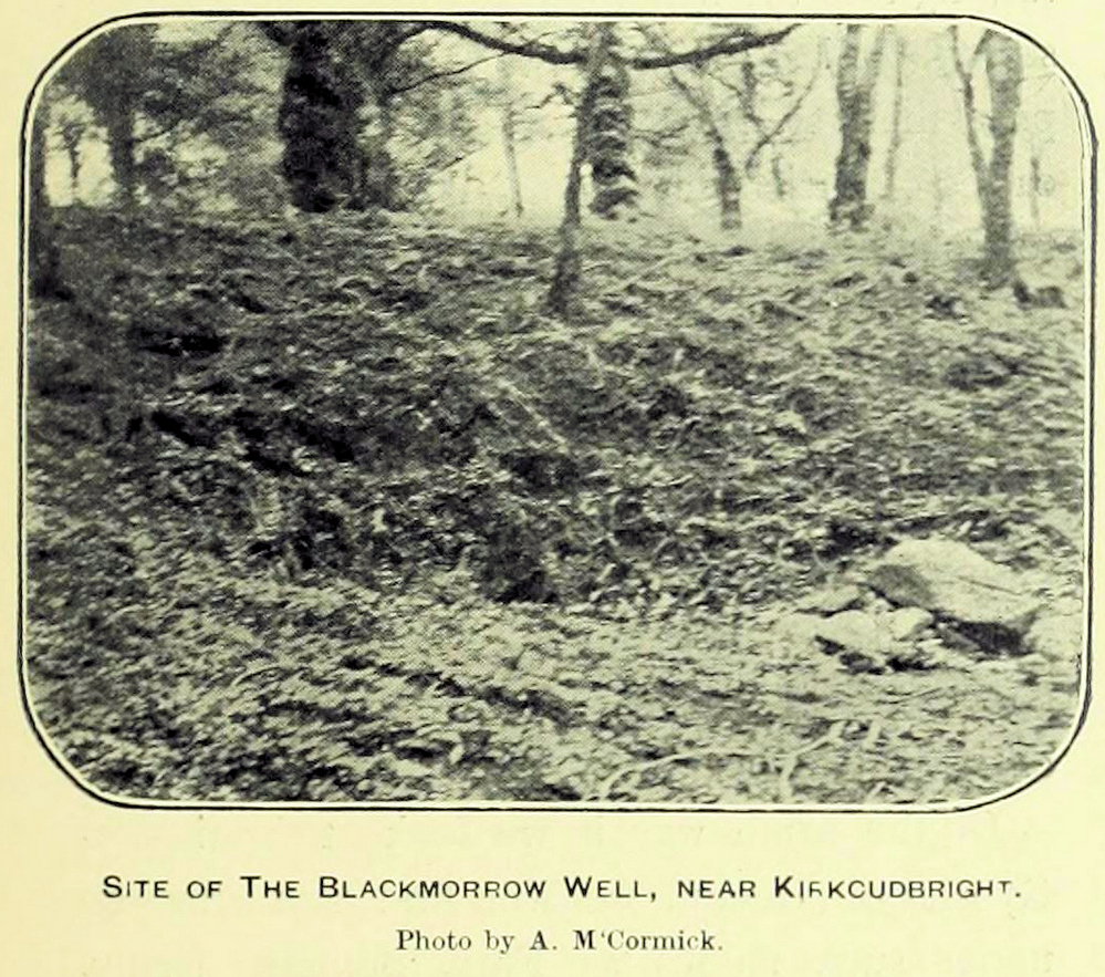
A curious little-known site with more of a Scottish genealogical history behind it. Mentioned in McCormick’s (1906) fascinating survey of tinkers in the Galloway region, the site was given a more succinct description in the Morris survey (1982), where they told that,
Well shown on 1854 mapBlack Morrow Well, c.1905
“a mile from the town in Black Moray (formerly Morrow) Road, a short distance from the road…was this well that the MacLellan family are said to have derived their crest of a Moor’s head impaled on a sword. The local story is that James II wanted to get rid of some gypsies infesting Galloway and offered the Barony of Bombie to anyone who could do so. MacLellan filled the well with potent liquor which the gypsy chief drank to excess and while he was in a drunken stupor MacLellan killed him, cut off his head and presented it to the King on the point of his sword, immediately receiving the barony as his reward.”
This story goes way back and was first mentioned in 1680. According to McCormick (1906), the name Black Morrow derived from the “More”, the title given to the leader of the so-called gypsy clan, “or, as tradition suggests, a man named Black Morrow, of Irish tinkler descent.”
Stone Circle (destroyed): OS Grid Reference – NX 7079 5018
Archaeology & History
This stone circle was destroyed sometime in the early 1780s by some moron who cared little for our ancient sites. Its destruction was described by Robert Muter in 1794—the earliest known reference to the site—when he told:
“Near the Roman camp there is a Druidical temple, which was destroyed within these eight years, by the hands of an ignorant Goth, who carried off the stones, split them, and applied them to build a contemptible bridge over an insignificant rivulet, called Buckland Burn. The stones were seven in number, of round granite, and of unequal sizes. The smallest at least three feet in diameter.”
In the 1850s, when the Ordnance Survey lads came this way to map and seek out the place-names of the area, the ‘Clownstane’ was one such place they listed. In seeking an explanation of the word, a local man told them the folk memory from seventy years prior:
“Mr. Bell of Balgreddan says the name Clownstane originated from the Stones of a Druid Circle which stood convenient to this place and which was broken up and removed to build a bridge near by.”
Fred Coles (1895) included the site in his survey of the Kirkcudbright circles, simply reiterating how,
“According to Dr Muter, the stones “were seized by some vandal for the building of Buckland Bridge.””
Stone Circle (destroyed): OS Grid Reference – NX 691 447
Archaeology & History
In an area littered with neolithic and Bronze Age remains, the great Fred Coles (1895) reported a stone circle that was destroyed sometime roughly between 1890 and 1911. When he visited the place with his colleague, Mr E.A. Hornel in 1887, the megalithic ring had already been tampered with. It was, he said,
“found to consist of five granite boulders, all of them large, in situ, and the ridgy grassy hollows of five others—removed, no one can say when. In the centre of this nearly true circle, 90 feet in diameter, is a slight mound, possibly artificial.”
In 1911, when the Royal Commission lads visited the area, they could find no stone circle and reported how “no information could be obtained concerning it” from the local farmer. This might have been because he destroyed it. Some land-owners do such things, as we know; but in this case we may never know.
The site was listed without comment in the Master’s magnum opus (Burl 2000), but he gave it the “uncertain status” category; whilst John Barnatt (1989) questioned whether this was a destroyed stone circle or merely a natural setting that Cole had misinterpreted.
References:
Barnatt, John, Stone Circles of Britain– volume 2, BAR: Oxford 1989.
Burl, Aubrey, The Stone Circles of Britain, Ireland and Brittany, Yale University Press 2000.
Royal Commission Ancient & Historical Monuments, Scotland, Inventory of Monuments and Constructions in Galloway – volume 2: County of the Stewartry of Kirkcudbright, HMSO: Edinburgh 1914.
Amongst a good cluster of petroglyphs, this ornate little fella may have been one visited by George Hamilton (1886) when he visited Balmae and outlying districts, seeking out petroglyphs! We don’t know for certain though, as his descriptions are somewhat vague. However, a few years later the great Fred Coles (1895) came a-wandering in search of the same carvings and, as happens in this line of business, uncovered a few new ones during his rummaging. This was one of them, which he described, very simply, as hiding
“but a few yards from Ross View Cottage, on its N.W. … (with) eight cups being associated with four rings and several grooves, both straight and curved.”
It was only a few years later when the Royal Commission lads (1911) came in search of it and they told how,
“the main design is a central ringed cup with a connected groove, and two outer cups which an outer circle curves eccentrically to enclose.”
But when Ron Morris (1979) explored the area in the 1970s, he was unable to locate this and a number of other carvings that had been reported by Coles. Since then, the carving has been relocated at the grid reference cited above. Also since then, a great deal many more carvings have been found in this locale by the experienced petroglyphic fingers of Maarten van Hoek. (1993)
Morris, Ronald W.B., The Prehistoric Rock Art of Galloway and the Isle of Man, Blandford: Poole 1979.
Royal Commission Ancient & Historical Monuments, Scotland, Inventory of Monuments and Constructions in Galloway – volume 2: County of the Stewartry of Kirkcudbright, HMSO: Edinburgh 1914.
van Hoek, M., “Balmae”, in Discovery & Excavation Scotland, 1993.
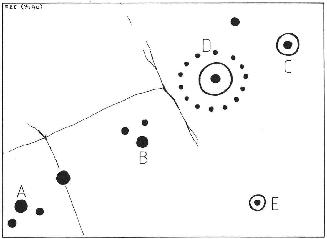
Cup-and-Ring Stone (lost): OS Grid Reference – NX 709 489
Archaeology & History
One of the lost High Banks carvings
The drawing here is another by the legendary Fred Coles, previously unpublished until Maarten van Hoek (1990) brought it out of the dusty archives of the Stewartry Museum, Kirkcudbright, and described it in his article on prehistoric rosette motifs. As with its fellow carving of High Banks 2, the location of the site remains unknown; and van Hoek wondered whether these two lost carvings “could have been located at the spot where now the little quarry at High Banks site is found.” Let’s hope not!
References:
Morris, Ronald W.B., The Prehistoric Rock Art of Galloway and the Isle of Man, Blandford: Poole 1979.
van Hoek, M.A.M., “The Rosette in British and Irish Rock Art,” in Glasgow Archaeological Journal, volume 16, 1990.