Once located on the south side of the stream between the ‘lost’ village of Eastburn and the cottages at Battleburn, this burial mound was one of many explored by the great J.R. Mortimer (1905), who told that:
“On June 24th, 1884, it measured about 40 feet in diameter and 4½ in elevation, and had a depression in the centre, which might have been caused by a former opening. By the old inhabitants of the neighbourhood it is known — like several other similar mounds near settlements — by the name of Mill Hill. A 15-feet square was cut from the centre and the natural ground beneath was found to consist of 3 feet of clay, resting upon chalk gravel. Through this clay and into the chalk gravel beneath was a roughly-cut trench, 3½ feet deep by about 3 feet wide, running north and south the whole width of our excavation and beyond, and from about the centre of the mound a similarly roughly-formed trench was observed to run east and west…”
In the sections that Mortimer and his fellows excavated, they uncovered various intriguing deposits, including the remains of ox, goats and horses. Later deposits were also located in and around the mound, showing it had been used in more recent centuries.
Folklore
Mortimer suggested this site was once an old moot site; comparing it to a place of the same name a short distance west at Kirkburn.
References:
Mortimer, J.R., Forty Years Researches in British and Saxon Burial Mounds of East Yorkshire, A. Brown & Sons: London 1905.
A 2½-mile long earthwork can obviously be reached from all sorts of ways, but coming out of Flamborough towards Bridlington (B1255 road) you can go down the Home Farm road and park up; and from here walk up the pleasant woodland walk, literally from coast to coast, where you’ll see good portions of the earthwork intact.
Archaeology & History
An impressive site by any means. Running from Dykes End on its southern edge for 2½ mile, roughly north, until hitting the North Sea again at the other Dykes End, this great earthwork had little to do with the Danes. It seems to have been originally started around 3000 years ago in the early Iron Age. As Mr Gower (1975) told:
“Excavations carried out at the end of the (19th) century revealed traces of a flint workshop and many arroheads were found… The earthwork is about 18 feet high and on the western side is a ditch 60 feet wide. Several openings are to be seen, but these are probably comparatively recent.”
Stone Circle (destroyed): OS Grid Reference – SE 748 282?
Archaeology & History
I’ve looked and looked for info on this seemingly lost site, but have found very little. It lent its name to the very woodland within, or on whose edges, it could once be found. First described as early as 1284 in the ‘Calendar of Patent Rolls’ – where is appeared as ‘Ringestainhirst‘ – and then in the Testamenta Eboracensia in 1391, it is mentioned several other times before falling into nothing but literary memory in the middle of the 19th century.
We don’t know for sure where the circle was located, though one Latin reference describes it in proximity to a hermitage once known as St. Mary Magdalen’s Chapel at Howden: “heremitae de Ryngstanhyrste.” The site would likely have been on the highest point in the locality, which may put it where the great church now stands, or perhaps on the more northern and western outskirts of the township. Are there any Howden historians reading this who might be able to throw a bit more light on the issue?
The great place-name authority A.H. Smith (1937) thought that the Ringstone Hurst (woodland) at Howden got its name from a “wood near the circular stone”; but modern etymologists would place a much greater likelihood that the woodland owed its name to the now lost stone circle that was once in this locality.
References:
Raine, James (ed.), Testamenta Eboracensia; or, Wills Registered at York, J.B. Nichols: London 1836.
Smith, A.H., The Place-Names of the East Riding of Yorkshire, Cambridge University Press 1937.
The faded remains of this old burial mound can vaguely be seen just off the right-hand (east) side of the B1248, across the road from the track which leads down to Burdale North Wold farmhouse, between Fimber and Wharram-le-Street.
Archaeology & History
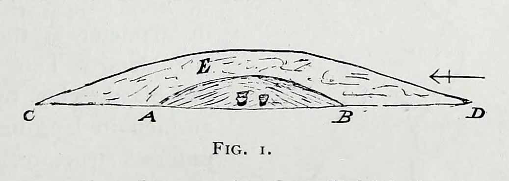
Known as Towthorpe Barrow No.1 in the Mortimer survey (1905), there are a number of prehistoric tombs and other remains close to this site (which will be described on TNA as time goes by). Some of you might think the lengthy description here a little unworthy, but I believe the extensive archaeological notes on this site by an archaeological legend, J.R. Mortimer, is a good indicator of the dedication and interest to which he gave each and every tomb that he opened (this’ll be the first of many). His slightly edited account told:
“This mound is situated near the centre of the (Towthorpe) group, close to High Towthorpe. Here the green lane…is crossed by the high road from Malton (B1248), through Wharram-le-Street… Part of this road, for some distance south and north of the barrow, is called ‘High Street’ by the old inhabitants of the neighbourhood…
“On 4 May, 1863, the writer, with the assistance of R. Mortimer and two workmen, commenced to open this mound. It was the first British barrow he had the pleasure of examining. A trench 10 feet wide was cut across its centre from the northern to the southern margin…
“The upper portion E, to a depth of 16 inches, consisted chiefly of the surface soil of the neighbourhood, the bottom part of which was reddened as if by the action of fire. Close below this was a stratum of wood and ashes and other dark matter, 2-3 inches in thickness; and then a lenticular bed of tough drab-coloured clay, 29 feet in diameter, and 12-14 inches thick in the centre, gradually thinning towards the circumference. The upper part of this bed of clay, which was in contact with the stratum of wood ashes, was reddened by fire; its under surface had a similar appearance and rested upon what seemed to be a second stratum of burnt and decayed matter, 2-3 inches in thickness, similar to that already described. The clay forming this lenticular bed contained numerous small fragments of grey flint, characteristic of the chalk of the neighbourhood. It must have been obtained from one of the valley bottoms (either Burdale, Wharram-le-Street or Duggleby), in which are exposures of the Kimeridge clay. In these places, angular pieces of flint and chalk crumble from the hillside, and mix with the clay, imparting a greyish colour to it. This is especially the case at Burdale, where there is a fine spring at the base of the chalk, and a small pond resting on the Kimeridge; and it is probably from this place that most of the clay for the construction of this barrow was obtained. It is not easy to explain the method by which the clay was transported, but several tons had evidently been used in this case. Many other instances in which material from a distance has been used in the erection of the barrows of this neighbourhood are recorded in (the Yorkshire Wolds).
“In the centre of the mound, at the base of the lenticular bed of clay and below the ashes (which probably represent the residue of a funeral pyre) stood two food vases, close together, and near to these, decayed bones (the remains of a human body) and a chipped flint. The smaller and more ornamented vase was situated to the south of its fellow. It measures 4.5 inches in neight, 5.5. inches in diameter at the top, and about the same across the shoulders. The ornamentation had been impressed on the plastic clay by a thin square-ended tool, about half-an-inch in length, which showed in the impression of a fine notched structure, and was equally divided into ten ridges about the size of the indentations on the milled edge of a shilling, and almost as truly cut. In the lower groove which runs round the vase are four pierced projections.
“The other vase is about 5 inches high and about 6 inches in diameter at the top and across the shoulders. Three encircling lines of short vertical cuts, rudely and apparently hastily made, previous to baking the vase, represent its entire ornamentation.
“During the excavation we collected from the material of the mound a dozen hand-struck flint flakes of various sizes, and a small splinter from the cutting-edge of a green-stone celt.”
Mr Mortimer returned to do further excavations here on Christmas Eve and Christmas Day in 1865, with the hope of finding more — but apart from a finely-cut knife made of black flint, nothing else was located. This was the first of Mortimer’s hundreds of diggings into the tombs and dykes of East and North Yorkshire.
References:
Marsden, Barry M., The Early Barrow Diggers, Tempus: Stroud 1999.
Mortimer, J.R., Forty Years Researches in British and Saxon Burial Mounds of East Yorkshire, A. Brown: London 1905.