Take the same directions as if you’re visiting the impressive Tormain (1) carving. About ten yards before you reach it, just at the top of the hill itself, almost the first flat stone you come across is the one you’re after. You’ll find it easily enough.
Archaeology & History
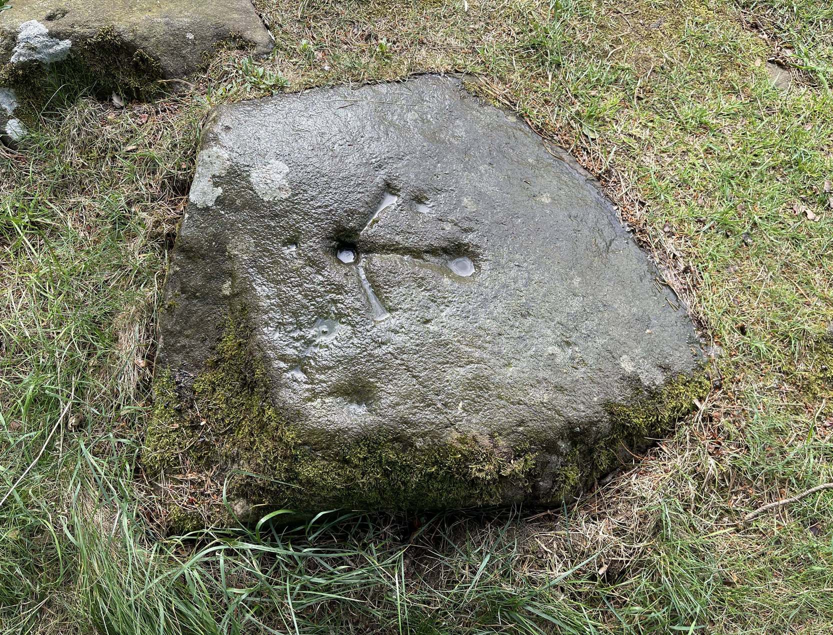
This is a notable design by virtue of the Ordnance survey lads marking it with an unusually large benchmark, utilizing at least one of the prehistoric cup-marks on their much more modern symbol. You can clearly see it in all the photos. The stone itself may have had a section of it cut or split from a once larger piece, probably in the 19th century when a lot of quarrying was being undertaken round here.
This carving was first described, albeit briefly, in John Smith’s (1874) piece on the nearby Witch’s Stone, where he told:
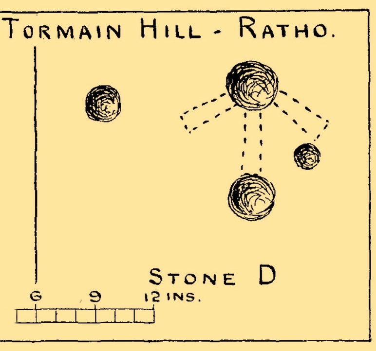
Allen’s 1882 sketch
“there is a group of three cup-like hollows near the highest summit of the hill; this last has, however, been altered in our own day by the officials of the Government Ordnance Survey combining them into one figure, by drawing from cup to cup their well-known and characteristic mark of the Queen’s ‘broad arrow.’”
To be honest, there’s not much more that can be said of it. A few years later when Romilly Allen (1882) surveyed all the Tormain stones, he simply wrote that,
“Stone D…lies 30 feet from stone A, and is the most northerly of the group; it is also the highest as regards level, and has an Ordnance bench mark cut on it… Round the bench mark will be found four cups, varying in diameter from 1 to 2½ inches.”
Not all of the cup-marks on this stone are prehistoric, as is obvious when you look at them close-up. Two, perhaps three of them are OK, with at least one of those that are attached to the Ordnance Survey mark widened and deepened when they came here in the 19th century.
Morris, Ronald W.B., “The Cup-and-Ring and Similar Early Sculptures of Scotland; Part 2 – The Rest of Scotland except Kintyre,” in Transactions of the Ancient Monuments Society, volume 16, 1969.
Morris, Ronald W.B., The Prehistoric Rock Art of Southern Scotland, BAR: Oxford 1981.
Royal Commission Ancient & Historical Monuments of Scotland, Inventory of Monuments and Constructions in the Counties of Midlothian and West Lothian, HMSO: Edinburgh 1929.
Travel along the B867 road from Bankfoot to Dunkeld (running roughly parallel with the A9) and you’ll reach the hamlet of Waterloo about one mile north of Bankfoot. As you approach the far end of the village, keep your eyes peeled for the small turning on your left and head up there for just over a mile. The road runs to a dead end at Meikle Obney farm, but shortly before reaching there you’ll pass this large standing stone on the right-side of the road, just along the fence-line. It’s almost impossible to miss!
Archaeology & History
This is one of “the large rude upright stones found in the parish” that William Marshall (1880) mentioned briefly, amidst his quick sojourn into the Druidic history of Perthshire. It’s an impressive standing stone on the southern edges of the Obney Hills that doesn’t seem to be in its original position. And it’s another one that was lucky to survive, as solid metal staples were hammered into it more than a hundred years ago when it was incorporated into the fencing, much like the massive Kor Stone 6½ miles south-west of here.
Site shown on 1867 mapWitch’s Stone at roadside
Shown on the first Ordnance Survey map of the area in 1867, its bulky 6½-foot-tall body stands all alone on this relatively flat plain, with open views to the east, south and west. It gave me the distinct impression that it was once part of a larger megalithic complex, but I can find no additional evidence to substantiate this. Call it a gut-feeling if you will. Intriguingly, the closest site to this are two standing stones just out of view literally ⅔-mile (1.07km) to the northeast, aligned perfectly to the Witch’s Stone! Most odd…
Folklore
The story behind this old stone is a creation myth that we find all over the country, but usually relating to prehistoric tombs more than monoliths. The great Fred Coles (1908) wrote:
“the common legend is told of a witch who, when flying through the air on some Satanic behest, let the Stone fall out of her apron.”
Marshall, William, Historic Scenes in Perthshire, William Oliphant: Edinburgh 1880.
Stewart, Elizabeth, Dunkeld – An Ancient City, Munro Press: Perth 1926.
Acknowledgements:Huge thanks for use of the Ordnance Survey map in this site profile, reproduced with the kind permission of the National Library of Scotland.
“there is a group of three cup-like hollows near the highest summit of the hill; this last has, however, been altered in our own day by the officials of the Government Ordnance Survey combining them into one figure, by drawing from cup to cup their well-known and characteristic mark of the Queen’s ‘broad arrow.’”