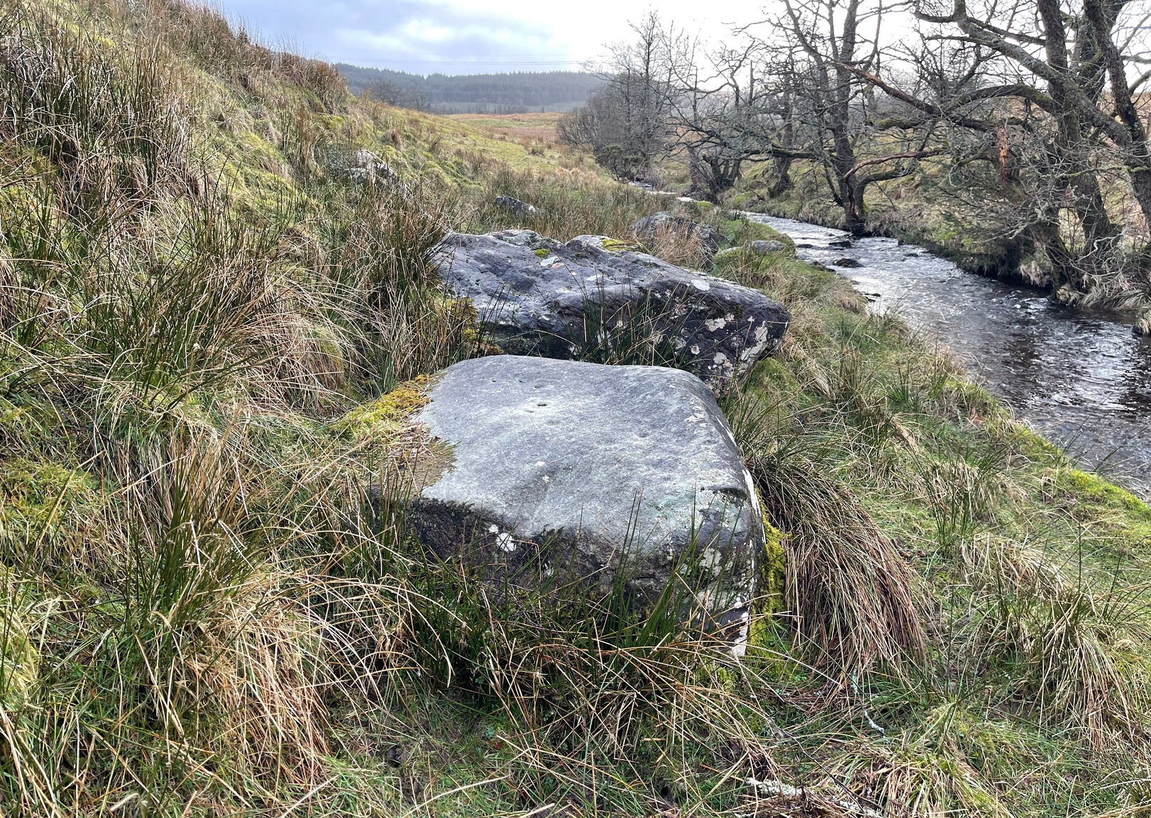
Park by the entrance to Ballochraggan, which is set back off the A81 between Aberfoyle and Port of Mentieth. Walk up the track, and just before you reach the cottage, notice the large boulder on your left, about 50 yards away. That’s it.
Archaeology & History
The Ballochraggan 1 Stone
This large dolmen-capstone-like boulder in front of the old cottage, was reported by Maarten von Hoek (1989) to possess about 10 faint cup-markings, with a large one near the centre of its upper surface. When Paul Hornby and I visited the site yesterday, several ‘cups’ were visible, but these were purely geological in nature; and even the large cup in the middle seemed somewhat dubious. The markings are the product of conglomerate rock, where smaller softer types of stone that are embedded in the boulder fall away, leaving cupmark-like indentations and other hollows. There are a lot of conglomerate rocks in these hills and it is essential that all students make themselves aware of the difference between the geological ‘cups’ and those forged by humans. In many cases this can be difficult, so apply the rule: if in doubt, kick it out—and err on the side of caution.
Some carvings in this region (and elsewhere in the country) possess conglomerate marks that have been enhanced and possess additional rings and carved lines. On this particular stone, such marks do not seem to exist. A dodgy example indeed…..
References:
von Hoek, Maarten, ‘Menteith (Port of Menteith parish): Rock Art Sites’, in Discovery & Excavation Scotland, 1989.
Acknowledgements: Huge appreciation to Paul Hornby for his photo and assessments.
Takes some finding this one! We parked up by the entrance to Ballochraggan on the A81 between Aberfoyle and Port of Mentieth. Walk up the track, then up the burnside past the house. Keep to its right-side and head uphill towards the very top of the forestry edge, staying in the grasslands. As you near the very top NE corner of the grassland boscage (NOT into the forest), about 100 yards before it, zigzag about through the gorse and keep your eyes peeled. It’s there!
Archaeology & History
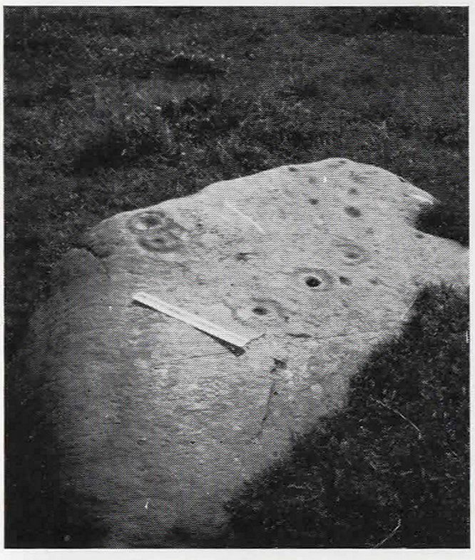
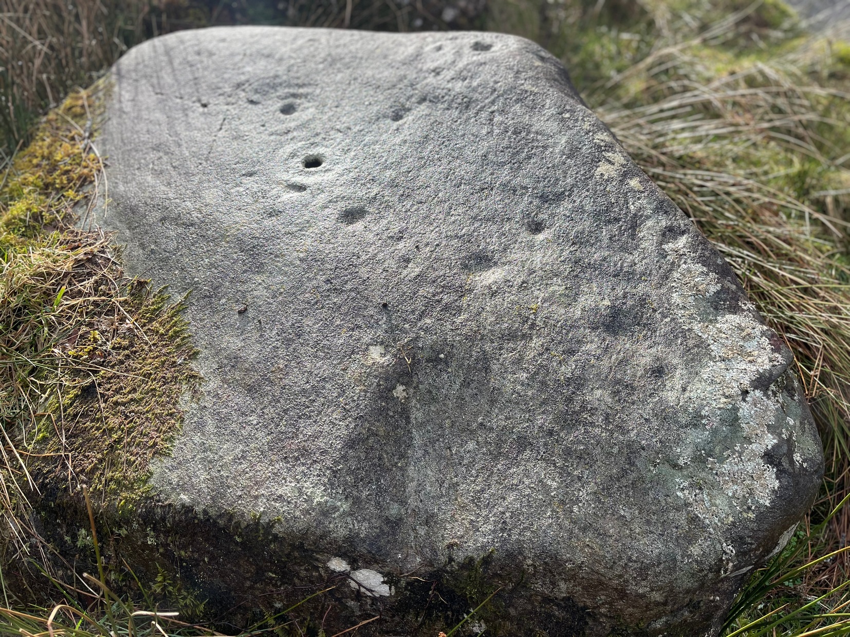
This is a small, flat, smooth piece of stone with a simple carving clearly visible, in a region replete with highly impressive multiple-ringed petroglyphs. Very little has been said of this design and even the Canmore lads tell us only that the carving “includes one cup and ring marking and two cups within an oval ring.” And that’s that! However, other faint lines are evident on the surface of the stone, with the single cup-and-ring appearing to have another partial second-ring encircling a section of it. Outlying this are very shallow worn lines that seem to bear the hallmarks of human interference, but they were difficult to see with any certainty and our camera didn’t pick up additional elements with any real clarity. What seemed to be another cup-and-half-ring (not visible in the photos) was just beneath the edge of the grass where the rock fell back into the Earth.
Ballochraggan12, under cloud
The most catching element of the design is the very obvious ‘eye’ symbol peering up at us as we look down. Whether this symbol was deliberate or not, we can be sure that the old archaeologist O.G.S. Crawford (1957) would have loved it and added it to his old dreams of eye goddesses!
Other carvings nearby will blow your head off! The recently discovered Mask Stone, right next to this Ballochraggan 12 carving, being just a taster of the things to come.
Crawford, O.G.S., The Eye Goddess, Phoenix House: London 1957.
Naddair, Kaledon, et al, ‘Menteith (Port of Menteith Parish): Rock Ccarvings’, in Discovery & Excavation Scotland, 19, 1992.
Royal Commission on the Ancient and Historical Monuments of Scotland, The archaeological sites and monuments of Stirling District, Central Region, HMSO: Edinburgh 1979.
Acknowledgements: Huge appreciation to Paul Hornby for use of his photos. Cheers mate!
On the A81 road from Aberfoyle to Strathblane, about a mile south of Aberfoyle take the tiny right turn (keep your eyes peeled!) to Gartmore. At the end of the village, turn right at the T-junction. Just over a mile along the tiny road, just over the tiny road-bridge, turn right again up up the dead straight road to Drymen for nearly a mile and park up. A dirt-track is on your right: walk along here for ¾-mile (1.2km) and in a large field on your left a huge rock sits (no carvings on it). Keep walking on the track and where the field ends, a path to your left runs above a small burn. Naathen, 150 yards along here, look down at the waters and there’s a clump of large rocks. Check ’em out!
Archaeology & History
Morris’ old photo (from PSAS 1967)
This stone and others were mentioned in MacNair’s (1973) essay in the popular history guide to the region, after it had seemingly been rediscovered a few years earlier by Ron Morris (1967; 1969), who listed it in his petroglyph catalogues. It was originally located at the top of the slope above the burn, but was rolled down here shortly after Morris discovered the cup-and-rings on it. The farmer at the time had made a bore-hole into the rock with the intention of blowing it up, but Morris found it just in time and the stone managed to survive!
Faint CnR’s just visible
It’s a large rock with a decent ornate design that was clearly visible when Morris surveyed it (see photo, right). It comprises of, “a cup-and-two-rings, 18cm (7in) diameter, 6 cups-and-one-ring (2 of which are tangential) and at least 8 cups. All rings are complete. Greatest carving depth 2cm (¾in).” There also appears to be a line of four or five small cup-marks running in a short line by one of the lower cup-and-rings, but these are very faint indeed. The double cup-and-ring mentioned by Morris is the one at the top-centre in my photo, but the next cup-and-ring down may also be a double-ring. At the top-right of the photo is where two cup-and-rings are conjoined.
Since being rolled down the slope to the side of the burn, the carving’s much more in the shadows and is more difficult to work out. Sadly on the day when I visited here, Nature bestowed on me a wet and cloudy firmament, so the design was even more difficult to see, as my photos illustrate.
Morris (1981) told that “other stones in the immediate vicinity bear possible cup-marks,” and one of these may exist just a couple of stones away (Corrie 2), leaning up into the grasses: this is another rock that has been pushed down the slope and has curious natural cup-markings on it, with one or two that could be man-made, but we need a geomorphologist to have a look at it and tell us one way or the other.
References:
Edlin, Herbert L. (ed.), Queen Elizabeth Forest Park, HMSO Edinburgh 1973.
MacNair, A.S., “History,” in Edlin’s Queen Elizabeth Forest Park, HMSO 1973.
Morris, Ronald W.B., “Stirlingshire: Corrie Farm (Gartnabrodnaig) – Cup Marks,” in Discovery & Excavation, Scotland, 1967.
Morris, Ronald W.B., “The Cup-and-Ring and Similar Early Sculptures of Scotland; Part 2 – The Rest of Scotland except Kintyre,” in Transactions of the Ancient Monuments Society, volume 16, 1969.
Morris, Ronald W.B., The Prehistoric Rock Art of Southern Scotland, BAR: Oxford 1981.