Balrobbie, Killicrankie, Perthshire

Cup-Marked Stone:  OS Grid Reference – NN 90884 62571

Getting Here

The Balrobbie Stone

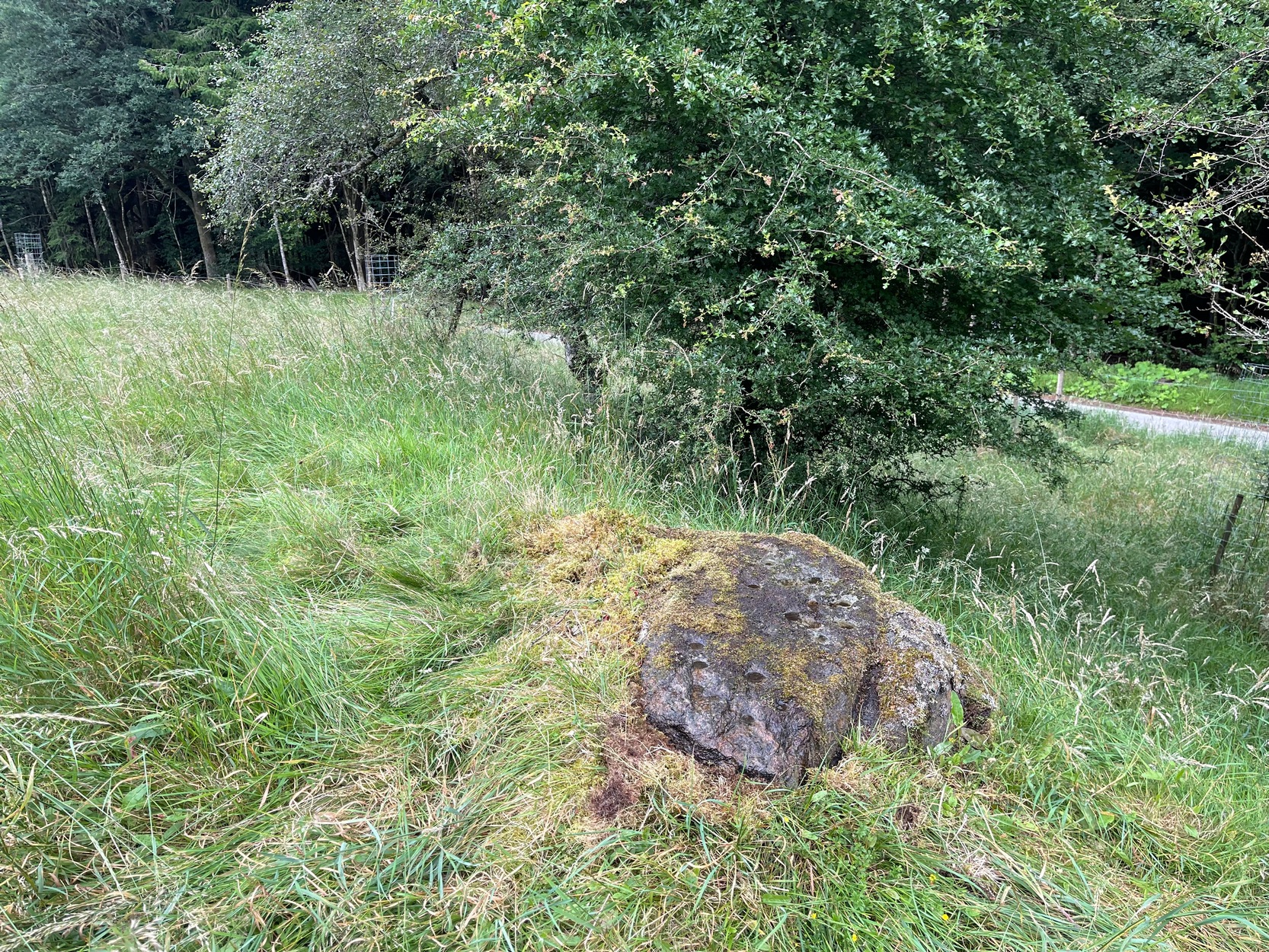
Roughly halfway between Blair Atholl and Pitlochry on the B8079 road is the village of Killiecrankie where, at the junction, you should take the road which leads you over the River Garry.  Crossing the river, follow the minor road swerving to the right and after nearly 200 yards bear left up the very minor road.  200 yards up there’s a hairpin bend; keep going up for about another 150 yards then walk into the overgrown grassland on your right where, just above an old hawthorn, a single notable rock protrudes.  Y’ can’t really miss it!

Archaeology & History

Some of the cups visible in poor light

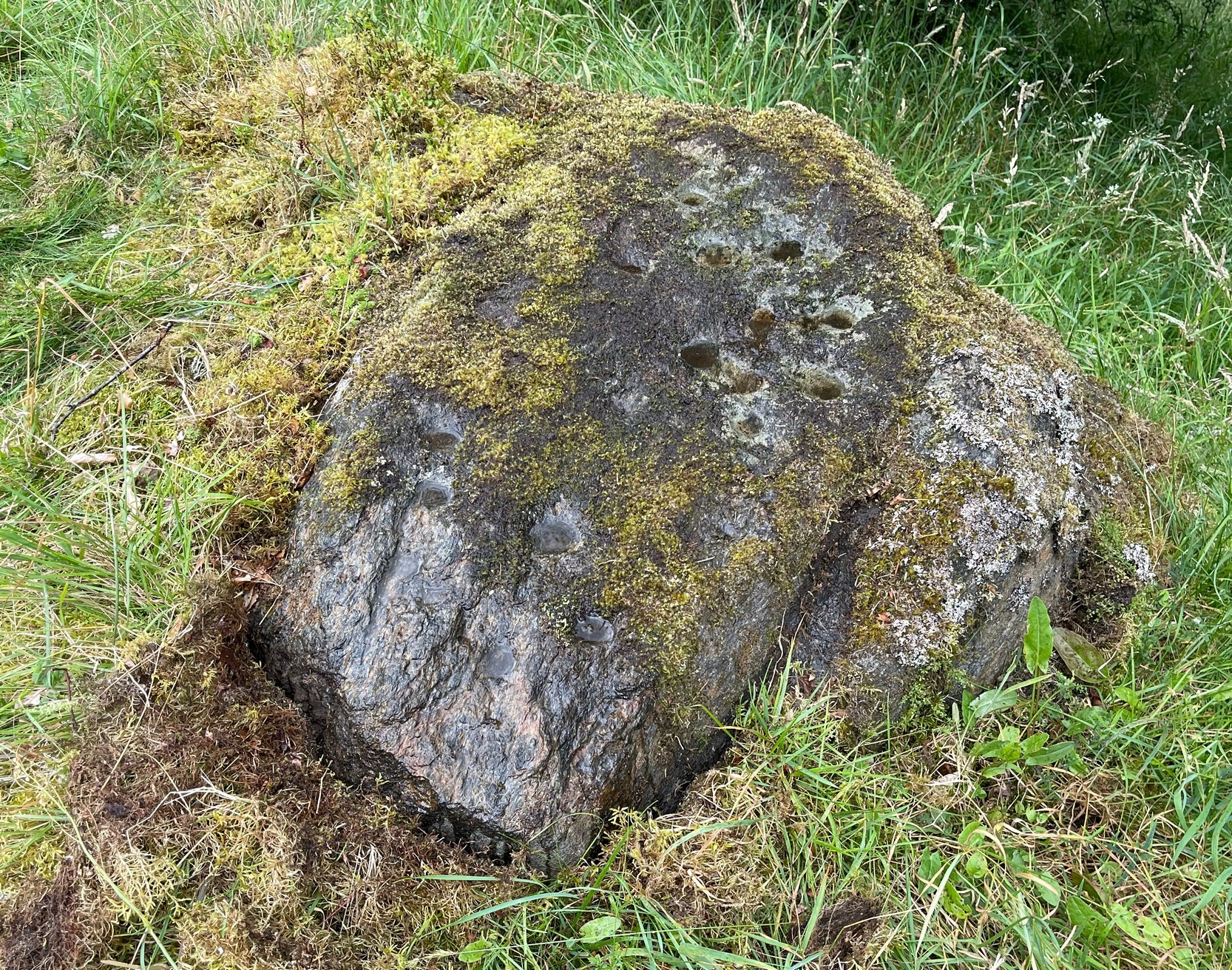
On my visit here recently, the day was grey and overcast which, in tandem with there being a reasonably decent cover of mosses living on the stone, prevented me from seeing the complete design of this petroglyph.  I was thankful that it’s not an overly impressive one, so couldn’t be too disappointed.  It was was rediscovered in recent years by George Currie (2005) on one of his many forays, which, in his typically evocative language, he described as: “Rock, 1.5 x 0.9 x 0.7m, a few metres W of the Tenandry road; 24 cups, largest 50 x 18mm.”  Most of the cup-marks are a good depth and easy to see when you’re stood next to it.  Sadly my photos didn’t manage to capture them too well.

A notable hut circle can be seen a short distance away up the slope, barely visible in the summertime.  The carving may have been executed by the people living there.  This is the only recorded cup-marked stone anywhere near here which, as rock art junkies will tell you, is unusual.  Where there’s one, others tend to be living close by.  Happy hunting!

References:

  1. Currie, George, “Perth and Kinross: Balrobbie,” in Discovery & Excavation Scotland, volume 6 (New Series) 2005.

Acknowledgements:  Huge thanks for use of the Ordnance Survey map in this site profile, reproduced with the kind permission of the National Library of Scotland

© Paul BennettThe Northern Antiquarian

Whooping Cough Stone, Struan, Perthshire

Legendary Rock: OS Grid Reference – NN 816 653

Getting Here

Old photo of the stone (after Duncan Fraser)

Up the A9 past Blair Atholl, a few miles later there’s the turning for Struan.  Scarcely a mile east of old Struan Church, head past the old farmhouse of Old Kindrochat and keep going eastwards along the edge of the trees for about 200 yards until you reach the sheepfold. There you’ll see a singular rock sitting alone by the fence. That’s it!

Archaeology & History

This little known healing stone was, at one time last century, of great repute in the Highlands. Today, very few people even know it exists. One of many rocks that were said to possess healing abilities, this one (obviously) was of great repute in the curing of whooping cough. But it wasn’t the rock alone that did the work here, for upon its edge was a small basin into which rainwater collected and this, when used correctly and in due accord with ancient ritual tradition, could enact the cure.  Mr Duncan Fraser said of this fascinating healing stone:

“The grey water-worn stone is about 4ft 6in long, 2ft 6in broad and 2ft high, with a deep gash on top, where the water lingers even in long dry spells. When full it holds about half-a-gallon. People were still coming here with their sick children as late as 1860 — and bringing a spoon made from the horn of a living cow. There was no cure without that.”

The ritual “spoon made from the horn of a living cow” was an important ingredient at another site with the reputation for curing whooping cough about 50 miles south of here, near Balquhidder. (see Whooping Cough Well, Killin)  What truly fascinates me is the origin of this stone and its medicinal virtues.  When  did the healing rites first start here – how long ago…?

References:

  1. Fraser, Duncan, Highland Perthshire, Standard Press: Montrose 1969.

© Paul Bennett, The Northern Antiquarian