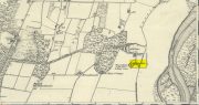
On the west-side of the River Spey from Fochabers, follow the road-signs taking you south on the B9015, and near Inchberry is a tiny road on your right (careful not to miss it). Go along here to the end of the long straight road and turn right, down the track. When you reach the trees, bear left along the track to St Mary’s, Orton, marked “Private road”. 🙂 Parking is limited to one car only but very quiet.
Archaeology & History
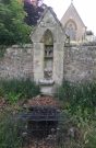
St Mary’s Well, Inchberry (21st Century Pict)
Set in a stunning location next to the river Spey with a magnificent view of Ben Aigan to the south, St Mary’s Holy Well and Pool is easy to find behind the Chapel / Mausoleum wall, dedicated to the Duff Family. There is a small stone basin in the wall which may have been the Chapel font. At the time of my visit the weather has been dry and sunny for some time. The pool below the iron grate has been recently cleared of leaves before my visit, with no standing water but the stones on the bottom of the pool looked damp. And with the cemetery above and behind the wall, perhaps it was for the better.
It was clear and running, said J.F.S. Gordon (1880) at the end of the 1700s, but when he came to write about it the flow “has ceased for many years, and is now only a feeble, filthy, stagnant Driblet for the use of cattle.” Pilgrimages were made here on the first Sunday in May, and water collected from the site was kept for a year, in return for an offering (usually a stone or other inanimate object) that enabled the magickal spirit of the well to enact cures.
Folklore
A site described by Watson (1868) as being “long held in superstitious reverence”, the well was said to cure whooping cough, eye problems and joint conditions. It had thoroughly un-christian shennanigans practised here by local folk, much to the consternation of the usual culprits! Visited extensively by people from far and wide, Mr & Mrs Morris (1981) told,
(21st Century Pict)
“The visits displeased the Kirk and there were various summonses to the Session for “going supersticiously to a Vell at Speyside” and of persons who “kneillit about the chappell and drank the water.” The minister at Ruthven reported that a large number had gone to the chapel well “thrie Saturdays before Lambas and thrie efter called the six silie Saturdayes, and that the conventions wer on the night or before day in the morning.” And “quhairas zierlie about Lambnes, the ignorantes repaired to ane wel at this kirk, called Our Ladie Wel, superstitiouslie, and kneeled about the said kirk, it is reportit that the evil is removed.” This may be the well associated with the White Witch, Dame Aliset, who cured a fairy child with simples and the well water.”
References:
Bord, Janet, Holy Wells in Britain – A Guide, HOAP: Wymeswold 2008.
Watson, J.& W., Morayshire Described, Russell & Watson: Elgin 1868.
Acknowledgements:Huge thanks for use of the Ordnance Survey map in this site profile, reproduced with the kind permission of the National Library of Scotland.
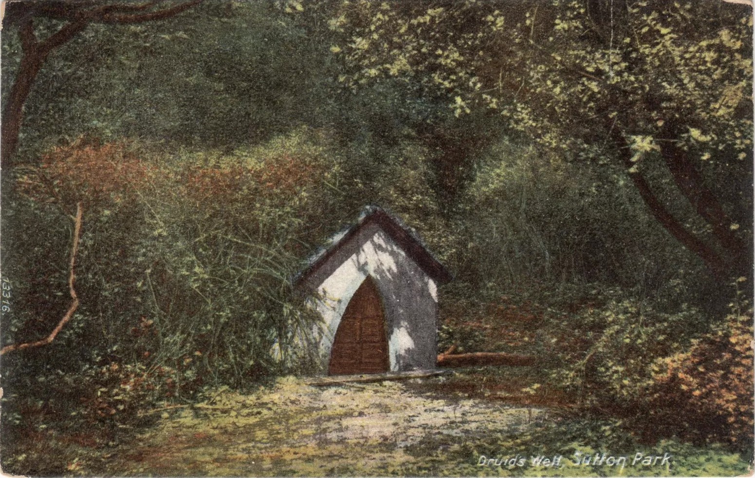
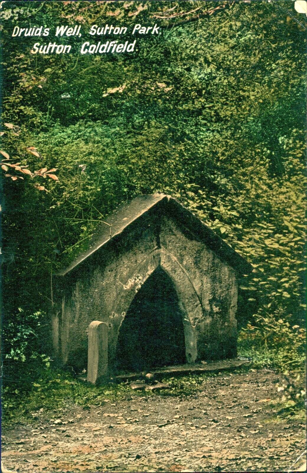
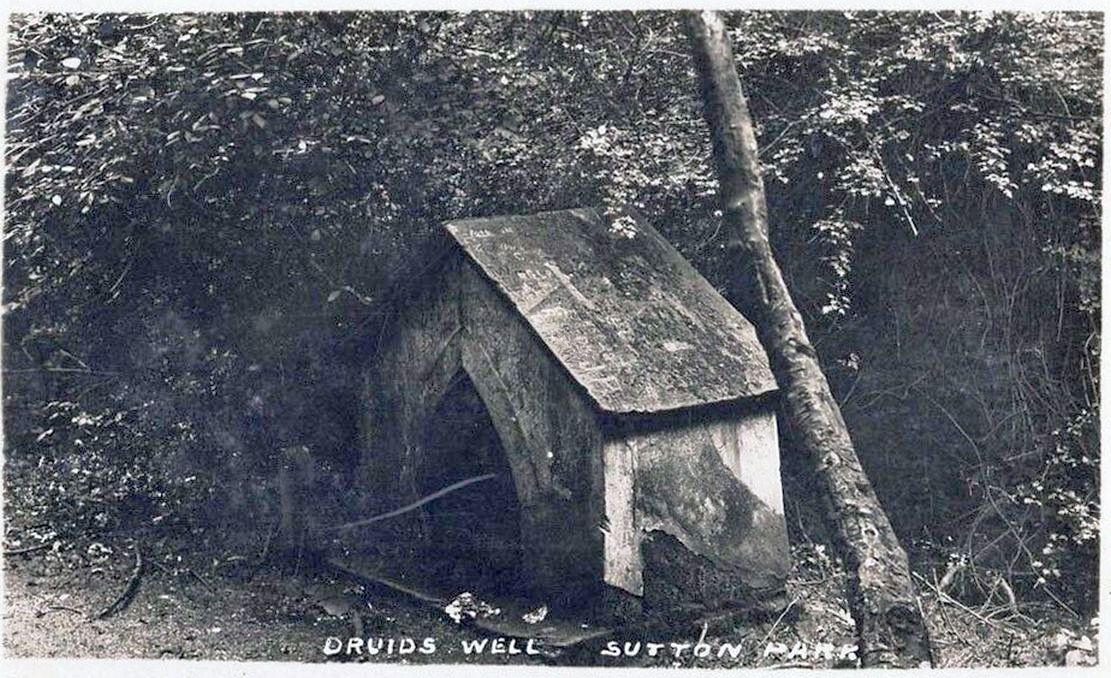
Highlighted on the 1884 Ordnance Survey map of the region and located beyond the far eastern end of Braceridge Lake, this legendary well has seen better days. A small well-house once covered the spring, but all we have left today is little more than a rectangular stone-lined concrete hole-in-the-ground where the waters collect (hopefully some local folk can bring it back to life). But in the 19th century it was well known, much frequented and maintained.
Not much seems to be known about its mythic history, as the traditions surrounding its dual pagan-christian dedication seem to have been forgotten. When the local writer Tom Burgess (1893) came to explore its history, he merely wrote:
“How it came to be called the Druids’ Well is not known, it is scarcely necessary to say that it can have no Druidical connection; it is very probable, however, that it was dedicated to Saint Mary long before the dam of Bracebridge Pool was made by Ralph Bracebridge in the reign of Henry V.”
Druids Well in 1917Druid’s Well in 1932
Jeremy Harte (2008) suggested that this well’s druidic association may have come from a local man, William Hutton who, in the middle of the 18th century, “speculated on a druid sanctuary near Sutton Coldfield.” But before Hutton, the 17th century Staffordshire topographer, Robert Plot, suggested that an arch-druid held residence on Barr Beacon, which is less than three miles west of here. This idea was echoed by Midgley (1904) who told that Barr Beacon “is supposed to have been a Druidical shrine.” Just over three miles to the northwest, the Druid’s Heath (a place-name derived, apparently, from an old family) at Aldridge also had its own array of folklore which, perhaps, may have had something to do with this well’s association. When Roy Palmer (1976) wrote about the Druid’s Well in his folklore survey, he told that Sutton Coldfield,
“is said once to have been the seat of the arch-druid of Britain; perhaps this was his well, which was later christianized.”
So much to choose from…
References:
Bord, Janet, Holy Wells in Britain – A Guide, HOAP: Wymeswold 2008.
Bracken, L., History of the Forest and Chase of Sutton Coldfield, Simpkin Marshall: London 1860.
Harte, Jeremy, English Holy Wells – volume 2, Heart of Albion press: Wymeswold 2008.
Midgley, W., A Short History of the Town and Chase of Suton Coldfield, Midland Counties Herald: Birmingham 1904.
Palmer, Roy, The Folklore of Warwickshire, Batsford: London 1976.
Acknowledgements:Huge thanks for use of the Ordnance Survey map in this site profile, reproduced with the kind permission of the National Library of Scotland.
Approaching Tibbermore from Huntingtower, turn left in the village and the site of the Lady Well is visible in fields on the left, just to the north of a bush growing on the north-south boundary fence on the east side of the roadside paddock before you get to the church.
Archaeology & History
On the day of my site visit I wasn’t able to get close to the site, owing to the subdivision of the roadside paddock by wire fences and the presence of horses. Growing crops barred access from the east. But it appears that all physical traces of the well have been destroyed, and the actual site of the well as shown on old OS maps now shows no evidence of it, but a large bush a few yards south may indicate the present site of any vestigial spring.
The site of the Well to the left of the bush
Hew Scott, in Fasti Ecclesiae Scoticanae wrote that the church at Tibbermore was dedicated to St Mary, and that there was a Well of St Mary. Tibbermore was a mensal parish of the Bishop of Dunkeld – i.e., its parish revenues etc, were accrued to the Bishop, who maintained a residence in the parish prior to the Reformation. Pennant wrote in 1772 that the church of Tibbir-moor took its name from a holy well dedicated to the Virgin Mary.
John Inglis in the Old Statistical Account wrote that the name Tibbermore was understood to be compounded of two Gaelic words, tuber and more, which signify a large well—referring probably to a plentiful spring of water immediately adjoining to the church-yard.
Watson, in his Celtic Place Names writes:
‘Tibbermore or -muir near Perth is supposed to mean ‘big well’ from a fine spring near the churchyard, but as this used to be called “the lady well”, the meaning may be ‘Mary’s well’, tiobar Moire, like Tobar Mhoire, Tobermory in Mull.‘
Can it be inferred from this that the spring was historically of great importance; firstly to have given its name to the parish and village and secondly to have been named after the Virgin Mary rather than a ‘lesser’ saint, and to have been a pre-Christian place of veneration and pilgrimage? Adding to this speculation is the presence of several cup marked stones within a mile or so of the holy well, which may possibly indicate a very ancient sacred landscape.
References:
Pennant, Thomas, A Tour In Scotland 1772, London, Benjamin White, 1776.
Inglis, John, Old Statistical Account for Tibbermore, Perthshire, 1791-99.
Scott, Hew, Fasti Ecclesiae Scoticanae, Vol. IV, Edinburgh, Oliver & Boyd, 1923.
Watson, W.J., The Celtic Place-Names Of Scotland, Revised Edition, Edinburgh, Birlinn, 2004. (originally published 1926).