Briscoe Rigg, Rigton, North Yorkshire

Settlement (destroyed):  OS Grid Reference — SE 2581 5100

Archaeology & History

Briscoe Rigg on 1851 map

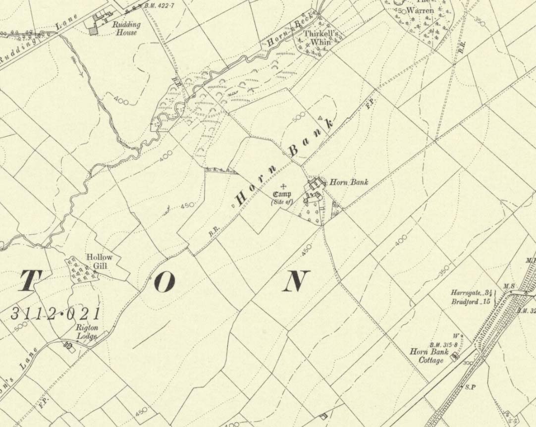
Highlighted on the 1851 OS-map of the area as a ‘Camp’, all trace of this ancient settlement would seem to have been destroyed.  It was already on its way out when the Ordnance Survey lads looked at it for a second time in 1888, finding barely a trace of it.  Thankfully though, when the clearer eyes of that great northern antiquarian Eric Cowling visited the site in the early 1930s, traces of it could still be made out.  Both he and fellow antiquarian, Mr B.J.W. Kent of Beckwithshaw, did their own investigations; and it is their notes we are most grateful for in describing this forlorn antiquity.  Mr Cowling (1946) wrote:

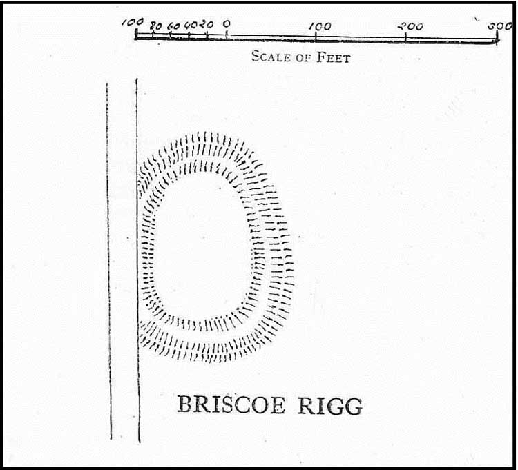
“On the highest point of the enclosed land on the east side of the Briscoe Rigg (to) Rigton road is a small entrenched site.  The enclosed area measures 130 yards from north to south and 70 yards from east to west.  The camp is six-sided, but this appears to be due to bad workmanship and layout rather than intention.  One gains the impression that the original plan was oblong and that the longer sides were bent to conform to the shorter ones.  It is slightly hollow and the whole area is almost levelled by heavy ploughing; the outer bank barely being one foot above the surroundings.  The ditch and outer bank now cover a spread of 60 feet.

“Recent hurried investigations by Mr Kent showed interesting details.  The area seems to have been occupied by hut-sites previous to the hurried digging of a trench some 16ft wide and 6ft deep, going down into the bed-rock nearly 6 feet.  Son after, the ditch was half-filled by boulders and earth amongst which was a fragment of pottery, black in colour and indefinite in type, but probably Roman.  When the ditch was half-full it was used for some time for cooking…”

Cowling’s 1946 site-plan

Cowling also told us there was “a tradition that tools, which by description appear to be socketed celts, were found here when the site was brought under cultivation”, in about 1840.  Mr Kent also discovered various flints hereby, many Mesolithic scrapers and “a fine Bronze Age barbed and tanged point and also a transverse cutting arrow point of the early four-sided types.”

Although these finds from much earlier periods show that people have been living and hunting in the area for an exceptionally long period, the settlement or camp at Briscoe Rigg was probably built in the early Iron Age period and continued to be used into Romano-British times (somewhere between between 500 BCE and 500 CE).

References:

  1. Cowling, E.T., Rombald’s Way, William Walker: Otley 1946.

© Paul BennettThe Northern Antiquarian


Horn Bank, Rigton, North Yorkshire

Horn Bank on 1910 map

Settlement (destroyed):  OS Grid Reference – SE 2905 5035

Archaeology & History

Upon the top of the old ridge where ran the ancient trackway between Rigton and Pannal, could once be found a multi-period settlement, long since gone – as happens all too often in this neck o’ the woods.  And unfortunately there doesn’t appear to be any sketch plans of the site.  It was first described by Edward Hargrove (1789) in his historical old rambles around Harrogate and district.  When the scribe reached Horn Bank, he told that here,

“was lately discovered the remains of several entrenchments forming three distinct enclosures, two of a square and one of a circular form.  Not far from these entrenchments, which were probably of Danish origin, was found, in May 1787, the umbo of a shield, with several other fragments of gilt brass…”

In William Grainge’s (1871) magnum opus he told that,

“At Horn Bank, on the crest of the hill east of Rigton, near a farm-house, are the remains of three camps—two of a square, and one of a circular form; they are probably of British and Roman origin. The location is a lofty and commanding one; but the ploughshare has so often passed over them that they are nearly obliterated.”

Just below the settlements Grainge also said how, “a fine spring of water was formed into a bath here many years ago, but the whole is now in a state of ruin.”  This would have likely been the main water supply for the people living here.  Harry Speight (1903) implied the same thing when he investigated the site, saying:

“At a place called Horn Bank, near Rigton, on the west side of the parish, on the crest of the hill on the north side of the Horn Bank farmhouse, there were formerly to be seen very distinct indications of three camps, each encompassed with fosse and rampart. Hargrove supposed them to be Danish, but as two of them were of a square or rectangular form, and the other circular, they were in all probability relics of the Romano-British contest, at first occupied by the native tribes and subsequently as a temporary camp and look-out post by their conquerors. The site commands a wide and uninterrupted view in every direction, while close at hand is a copious spring of good water. This spot many years ago was converted into a bathing-place, but is now broken down and abandoned… The site has long been ploughed, and little or no trace of these earthworks is now discernible.”

The only thing Eric Cowling (1946) could find when he came to the place were faint scars of walling whose shadows were highlighted by the sun when the conditions were just right.  He thought the settlements were Iron Age in nature, but would have continued to be used in subsequent centuries by local people.  It seems a sensible suggestion…

References:

  1. Cowling, E.T., Rombald’s Way, William Walker: Otley 1946.

  2. Grainge, William, History & Topography of Harrogate and the Forest of Knaresborough, J.R. Smith: London 1871.

  3. Hargrove, E., The History of the Castle, Town and Forest of Knaresborough with Harrogate, W. Blanchard: York 1789.

  4. Speight, Harry, Kirkby Overblow and District, Elliot Stock: London 1903.

© Paul BennettThe Northern Antiquarian