Healing Well (destroyed): OS Grid Reference – NS 5996 6406
Also Known as:
Arms Well
Archaeology & History
1865 OS-map of Arns Well, Glasgow
Taking its name from the local dialect word relating to Alder trees (Alnus glutinosua) that grew above the source of the waters, Arns Well had already been destroyed by the end of the 19th century, but prior to this it was renowned as one of the social gathering places in Glasgow Green. Highlighted on the original Ordnance Survey of the area in 1865, Arns Well was also a place where artists and poets gathered – and a number of old prints of Glasgow were drawn from here.
Originally the waters emerged from marshy ground and used to be known as “the Peat Bog,” but by 1777 a small well house was built to contain the waters and make it a feature in the wider architectural landscape of the Glasgow Green park area. Once the spring had been channelled, its waters “were considered to be amongst the best to be had in Glasgow, particularly for making tea and adding to whisky.” In James Clelands’s (1813) municipal survey of the area he told how some thought that the water supply from Arns Well was “inexhaustible.”
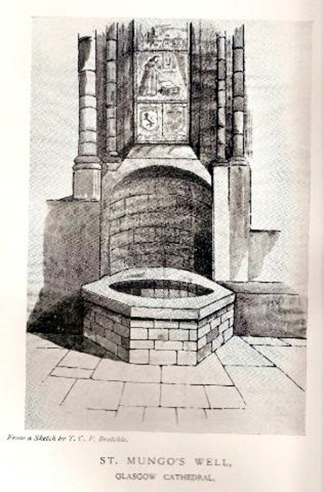
Not to be confused with the sacred well of the same name found along Gallowgate a short distance to the south, the waters of this ancient well have sadly fallen back to Earth. The structure built above it, however, is thankfully still preserved inside the Cathedral, as visitors will see.
Folklore and history accounts tell its dedication to be very early – and the tale behind the erection of the cathedral is closely associated with the waters themselves. Indeed, if the folklore is accepted, we find merely a transference of early animistic ideas about the death of an ancestor placed onto this early Saint, with a simple association in the formula of: tomb, holy site and architectural form. It could almost be Bronze Age in nature!
The lengthiest (and best) description of St Mungo’s Well was by Mr Brotchie (1920) in a lecture he gave on the city’s holy wells in April 1920, which was thankfully transcribed by the local history society. He told us:
“It seems to me that Glasgow in a very particular degree is a case that illustrates emphatically the existence of the early cult of the sacred fountain (sketch attached)… How came it to be there? In itself it represents the very beginning of Glasgow. It was to the little spring on the hillside overlooking the Molendinar that there came the earliest of christian missionaries, Ninian. All that we know of Ninian is from the account of Jocelin, the monk of Furness, who tells us that “ane holy man Ninian cam to Gleschu or Glasgow in the third century”, and made his cell on the banks of the Molendinar. When Kentigern or Mungo came to Glasgow in the sixth century, he made his settlement near a certain cemetery, which had long before been consecrated by St. Ninian, and which at the time when Jocelin wrote (twelfth century), was “encircled by a delicious density of overshadowing trees.” The crypt of the Cathedral—in reality an under church of extraordinary beauty of design and magnificence of mason work—is the shrine of St. Mungo, who is buried there, and the whole design of the lower church shows that the architect who in 1230 planned the building…built his scheme up with the idea of providing a shrine for the saint’s tomb and his holy well.
“The well is in the lower eastern corner of the church just opposite to the chapter house. John Hardying, the chronicler, who visited Scotland in 1413, states that St. Mungo’s shrine was then the centre of the life of Glasgow. In 1475 James III, on account of his great devotion to St. Kentigern, granted three stones of wax yearly for the lights at the tomb of the saint in the cathedral, near his holy well.
“St. Mungo adopted this well from the pagans of the district and changed its purpose from evil to good. Beside it he erected in 560 his little wattle hut where he died. He was buried inside it, and when the great cathedral was built the holy well was included within its walls…
“St. Mungo’s Well was a place of pilgrimage to the early christian fathers, and we find it described as “an idolatrous well” in 1614. In 1579 we have a public statute prohibiting pilgrimages to wells, and in 1629 the Privy Council denounced these pilgrimages in the strongest terms, it being declared that for the purpose of “restraining the superstitious resort of pilgrimage to chapels and wells, which is so frequent and common in this kingdom, to the great offence of God, scandall of the kirk, and disgrace of his majesties government,” that commissioners cause diligent search in “all such pairts and places where this idolatrous superstition is used, and to take and apprehend all such persons of whatever rank and qualitie whom thay sall apprehend going on pilgrimage to chapels and wells.” That decree was issued under the Dora of 1629. But all in vain. The custom of visiting chapels and wells had become a habit – and habits, as we all know, though easily formed are difficult to break. The wells continued to be visited by stealth if need be.”
Whilst I’m in Glasgow (big thanks to Aisha!) I thought I’d check out any remaining heathen sites that might still be visible. Many have perished of course, beneath the weight of religious industrialism—this one included. Even when the Ordnance Survey lads came here in 1858, it had already been destroyed. All that we now know of it comes from the writings of the earlier historians like Walker (1883), Renwick (1921) and co.
Known in early records as St. Theneu (mother of the legendary St. Mungo, who also had sacred wells dedicated to him in Glasgow, Gleneagles and much further afield), trackways and burns hereby were also named after this curious character, and a chapel was also commemorated to her, which fell into ruin several centuries ago. Its position was highlighted on a late-16th century sketch of Glasgow village—as it was then—immediately south of the chapel, just north of the River Clyde. The best description we have of it comes from a detailed paper on the holy wells of Glasgow by a Mr Brotchie (1920), who told:
“Where the subway station of St. Enoch’s Square stands…there was at one time the well of St. Tenew, the mother of St. Kentigern or Mungo. It is thus described by a writer in 1750, “The ruins of a small chapel stood beside the well whose waters were sheltered by a bush, on which were to be seen, especially in early summer, bits of rags of all kinds and colours, while in the well itself enterprising boys were wont to get small coins. The rags and the coins were the offerings of people, principally women, who came to drink of the waters of St. Tenew’s Well, and left these trifles as thank offerings.”
“This ancient well of St. Tenew stood near a chapel erected over the tomb of St. Tenew, and the ground in its vicinity remained sacred in the eyes of the faithful as the last resting place of the holy woman who had watched the infant steps of the great apostle of the Cambrian Britons, St. Mungo, the patron saint of Glasgow. The Trongate and Argyle Street, which now stretch westwards from the cross, were in old times a country road leading to St. Tenew’s chapel, kirkyard and holy well. In a deed of 1498 mention is made of “the blessed chapel where the bones of the beloved Tenew, mother of the blessed confessor, Kentigern, rest.” When M’Ure wrote his History of Glasgow in 1736, the remains of this old chapel and kirkyard were described as standing “in a solitary spot in the country surrounded by cornfields.” Looking westwards from St. Tenew’s Well in 1750, a writer describes the scene as “open country, pastures and cornfields, rude-looking country homesteads, barns and other farm buildings, and enclosed kailyards,” where now stand the busy arteries of Jamaica Street, the Caledonian Railway Station, and the miles of tenements that stretch westward to Anderston, Finnieston and Partick.
“We have a comparatively recent record of the holy well of St. Tenew in the statement of the late Mr Robert Hart, who told M’George that he had been informed by an old man, a Mr Thomson, who had resided in the neighbourhood of St. Enoch’s Square, that in the beginning of the last century, say 1800, he recollected the well being cleaned out, and of seeing picked from the debris at the bottom many old coins and votive offerings. St. Tenew’s Well was a holy well. For centuries it was a place of pilgrimage and was much resorted to for cures, especially in pre-Reformation days. In 1586, James VI, addressed a letter to Mr Andrew Hay, commissioner for the west of Scotland, condemning the practice of people making pilgrimages to wells and chapels, but the royal edict was powerless to stop the practice and St. Tenew’s Well was resorted to by people in trouble as long as it was in existence. The road that led to it was known up to the 15th century as St. Tenew’s Gait or path. Indeed, it was so named till 1540, when the name of Trongate begins to make its appearance in old city deeds. This name, of course, owes its origin to the granting in 1490 by James IV, to the Bishop of Glasgow of the privileges of a free tron in the city—hence our Trongate of today.”
In days of olde, close to the modern M8 on the edge of the modern industrial estate north of Eastfield, was once an old solitary tomb whose home had laid here, undisturbed, until the coming of the Industrialists. Thought to have been a Bronze Age tumulus, it was destroyed sometime around 1768 according to the regional historian David Ure (1793) who told that,
“A small mound at Hamilton Farm was levelled about 25 years ago. In it was found a “stone coffin” containing human bones.”
The Royal Commission (1978) lads think this may have been the same prehistoric tomb that was reported found on the nearby estate of Farme and destroyed that same year. We have no idea what became of the remains and no trace is left of the site.
References:
Royal Commission on Ancient & Historical Monuments of Scotland. Lanarkshire: An Inventory of the Prehistoric and Roman Monuments, HMSO: Edinburgh 1978.
Ure, David, The History of Rutherglen and East Kilbride, Glasgow 1793.
There is very little known of this once proud standing stone, said by one writer to have been about 12 feet long: six-feet of it in the ground and the other six-feet above ground. A decent monolith by anyone’s standard! But some dickheads forty years or more ago thought it a good idea to destroy the site, or as it was diplomatically put, “was removed in advance of road widening.” Vandalism no less – though it’s demise was recorded by the Department of the Environment “on behalf of the Inspectorate of Ancient Monuments.” (DES, 1973)
A local journalist called Andrew McCallum described the site in his unpublished manuscript on the history of the parish of Mansewood, telling it to be near Cowglen:
“near Boydstone Road, midway between Kennishead and Barrhead Road. 6 feet above the ground, and at least as many below. Age and purpose are unknown.”
Some thirty years later, Miss Adamson (1973) told us that,
“The straight-sided block had its base set on yellow sandstone. Immediately above the bedrock small stones and earth had been packed against the W and N faces of the standing stone. On top of the packing were two boulders set at right angles to wedge the sides of the stone. No burials or cremations were found.”
Though on this latter remark we have to consider the possibility that the standing stone may once have accompanied a burial, as the nearby place-name ‘Carnwadric’ indicates a cairn, or burial site. A field-name survey of the immediate region may prove valuable.
References:
Adamson, H., “Glasgow: Boydstone Road – Standing Stone,” in Discovery & Excavation in Scotland, 1973.