An Tiobairt, Kenmore, Perthshire

Healing Well (site of):  OS Grid Reference – NN 7667 4446

Also Known as:

  1. Town Well

Archaeology & History

On the narrow long and winding south-road along Loch Tay, from Kenmore towards Acharn, just a couple of fields past Portbane could once be seen, above the left-side of the road in the trees, a reputable healing well known by local people from Aberfeldy to Killin.  The regional historian William Gillies (1925; 1938) described its dying memory more than a hundred years ago.  Today, as the region is all but infested by little other than holiday-homers, there is little hope of finding actual locals who’ll know of the place.  Mr Gillies told the Well to be,

“about 1 mile west from Kenmore, and close to the public road leading to Acharn.  At one time it may have been a dip well, but, now the spring issues as a  strong spout from the bank. I  have not been able to ascertain for what ailment its waters were considered a remedy, but consumptive persons have been known to develop a great craving for this water and had it brought to them.  It is still called An Tiobairt, and no doubt gave its name to the old village which at one time was situated some distance above it on the farm, and which was known as Bal-na-tiobairt. The old dry stone walls may still be seen.”

The ancient village has long since gone.

After rainy days a good boggy arena may be had in the trees here—which is all that now remains of the curative waters… much like the even more important rag-well that once ran on the slopes above the nearby Acharn Falls.

References:

  1. Gillies, William A., “Notes on Old Wells and a Stone Circle at Kenmore“, in Proceedings Society of Antiquaries, Scotland, volume 59, 1925.
  2. Gillies, William A., In Famed Breadalbane, Munro Press: Perth 1938.
  3. Morris, Ruth & Frank, Scottish Healing Wells, Alethea: Sandy 1982.

© Paul Bennett, The Northern Antiquarian
Fuaran Barain, Acharn, Kenmore, Perthshire

Sacred Well:  OS Grid-Reference – NN 7580 4302

Also Known as:

  1. Acharn Well
  2. Barane’s Spring

Archaeology & History

I was up here again not long ago and forgot to check on the welfare of the waters here (bad of me, I know…), instead just walking past to have a gander at the impressive stone circle on the tops.  The site has been neglected, perhaps due to William Gilllies’ (1925) initial description of the place in the past tense.  In a short survey he did of some of the healing wells of the region, this one, “above the Falls and close to the old bridge known as Drochaid Bhragaid (the bridge of the brae)” was where,

“until a generation ago, people were in the  habit of going there to wish, when they threw in small offerings.  It has now fallen into neglect and is absorbed in the marsh.”

The spring and its muddy section can be seen on the west side of the waters, just above the old bridge, as affirmed in Gillies’ (1938) later magnum opus, where he found it to be named the Fuaran Barain, or Barane’s Well—although he failed to disclose the origin of the name and the stories behind it.  It was used as a rag well, as branches in the trees above the spring were bedecked with pieces of cloth, along with offerings being made, in the hope that the spirit of the waters would impart good welfare on celebrants with humility.  Sympathetic magick at ancient sites in this neck o’ the woods was widespread until very recently by many a local (the real stuff—not this neopagan or neo-druidic stuff).  It was simply a part of life whose traditions went way way back into ancestral memory—as things should be…

References:

  1. Gillies, William A., “Notes on Old Wells and a Stone Circle at Kenmore“, inProceedings Society of Antiquaries, Scotland, volume 59, 1925.
  2. Gillies, William A., In Famed Breadalbane, Munro Press: Perth 1938.

© Paul Bennett, The Northern Antiquarian

Queen’s Wood, Acharn, Kenmore, Perthshire

Cup-and-Ring Stone:  OS Grid Reference – NN 7640 4291

Also Known as:

  1. Canmore ID 25010

Getting Here

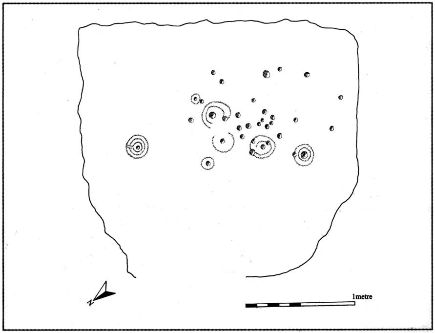
Ornate cup-and-ring in Queens Wood (after RCAHMS 2004)

From Kenmore, take the road towards Acharn on the south-side of Loch Tay for about a mile. Just as you go out of Acharn, watch for the small road of Queens Drive on your left going uphill. Go up here, following the tree-lined burn (stream) towards the superb Falls of Acharn, crossing the track over it and winding uphill still, until the track veers left across open fields towards the large woodland 400 yards east.  Just before the track meets the trees, notice the small burn running into the woods.  Follow this for some 200 yards – and where it bends more sharply to go uphill, keep going for another 75 yards upstream until you meet with another opening going east.  The rocky outcrop here is where this carved stone is found.  Look around!

Archaeology & History

Hidden deep within the woods where wet feet and good ankles come together, is this fine example of a cup-and-ring stone, perhaps having something in times of olde to do with the meeting of the waters.   A cluster of urisks and prehistoric remains scatter this lovely rolling section of southern Loch Tay, but I’ve found nothing specific to this bitta woodland that might give added mythos to the site.  The carving was described in Mr Stark’s (2005) fine little work on the local rock art, saying:

“A rock outcrop, situated in woodland between Acharn Burn and the burn running down to Remony House, bears at least thirty-six cupmarkings.  There are twenty-four plain cups, three cups each with a single ring, three cups each with double rings, and a cup surrounded by three faint rings, which has a gutter leading to the NW.  The cups range from 40mm to 75mm in diameter and from 60mm to 120mm in depth.”

The next time we visit the place, I’ll make sure I get some good photos – and visit the stone circle and settlement a few hundred yards further up the hill…

References:

  1. Stark, Gordon (ed.), Cupmarked Stones in Strathtay, Breadalbane Heritage Centre 2005.

© Paul Bennett, The Northern Antiquarian