Cursus: OS Grid Reference – NZ 3555 5381
Also known as:
- Hasting Hill
Archaeology & History
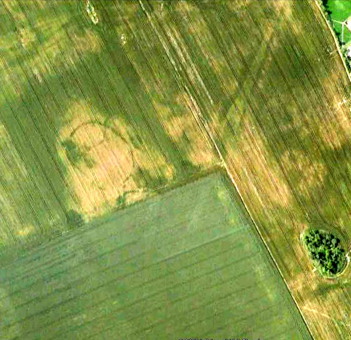
This site was discovered in the 1980s, following aerial surveying of the region. The survey uncovered a number of previously unknown archaeological monuments in relative proximity to each other; the Hastings Hill cursus being just one. There was also a causewayed enclosure and some round barrows some 700 yards south of Hastings Hill Farm. Although no distinctive remains of the earthworks can still be seen on the surface, limited excavation confirmed that significant remains survive beneath the ground. (in the aerial image here, note that the cursus in question aint the long thin crop-mark running to the top-left, but is the small, slightly rounded-end linear feature nearly touching the bottom-right of the oval enclosure)
A brief description of the remains on the Sunderland Council website gives the following information:
“Sections of the ditches of both the cursus and causewayed enclosure were excavated by the Department of Archaeology, University of Durham in 1980. The cursus is orientated north-south. At its northern terminus the cursus is 47m wide and is defined by a 1m wide, asymmetrical ‘V’ shaped ditch, which was 0.4m deep. The southern terminus has not been identified, but the cursus is at least 400m long. The causewayed enclosure lies 10m north west of the northern terminus of the cursus. It is an irregular oval, 92m by 65m, with its long axis orientated north-west, south-east defined by a 1m-2.2m wide ditch, which is 0.2m-0.3m deep. It has entrances in the north west and south east perimeter of the enclosure. One of the round barrows, which is 9m in diameter, is on the eastern perimeter of the enclosure. The other round barrow ditches are located just east of the cursus, 400m south of the causewayed enclosure. One of these has been measured at 20m-22m diameter. The cursus, causewayed enclosure and round barrows are interpreted as being of Neolithic date.”
References:
- Horne, P.D., MacLeod, P. & Oswald, A., ‘A Probable Neolithic Causewayed Enclosure in the North of England,’ in Antiquity Journal, March 2001.
© Paul Bennett, The Northern Antiquarian
I live very close to this site and though it may be helpful to provide some information about the site and the wider context in which it sits.
A walk along the edge of the fields to the West of this site reveals a great deal of natural flint, most of which is unbroken and unworked, possibly turned up by the plough from old stream beds that may have once run through the area as well as the glacial till that underlies most of the northeast. A significant amount for burnt flint and a few worked flints and agate appear around a rise immediately West of the enclosure, next to the road. The topsoil at the summit of the rise is so shallow that any archaeological features will most likely have been destroyed. The rise it’s self is a prominent feature in the undulating topography of the area. Examination of what the topography would have been like before significant changes made by the introduction of roads and industrial farming to the area would reveal a landscape difficult to navigate by todays standards.
In the wider context of the local prehistoric landscape the cursus sits South of hasting hill which is topped with a previously excavated burial mound. Humbleton hill a mile or so to the East of the site was once topped with a burial mound and possible enclosure which have long since been destroyed. Tunstal hills further to the east have both had burial mounds and worked flints found on them. Warden Law to the South had a number of Neolithic burial mounds as well as Mesolithic worked flint finds and Seven Sisters burial mound lies West of Warden Law with evidence of Mesolithic activity also recorded.
To the South West of Hasting Hill is the prominent Herrington hill which runs west in a crescent to Newbottle. As far as I am aware no prehistoric feature have been recorded along this hill but in the fields to the West at the foot of the hill I have found a number of worked flints, most likely Neolithic which include scrapers, burins and various worked flakes.
To the North West of Hasting hill lies Penshaw Monument which is a speculated, but unconfirmed prehistoric hill fort or enclosure. A number of flints have been found in this area and recorded in antiquity.
North East of the site evidence of bronze age settlement has been found near the river Wear at Hylton as well as a dug out canoe and Bronze weapons and axes dredged from the river during the days of shipbuilding.
Further features and burials have been recorded across Sunderland and in villages to the south of Houghton le Spring but most now have been replaced by suburbs or destroyed by open cast mining of farming.
Overall the archaeological evidence remaining after heavy industry, mining and agriculture in the area suggest this relatively small section of Sunderland has seen a large amount of prehistoric activity and habitation. This is easy to understand as the coastline provides large quantities of flint and hard stone from the glacial till that underlies the whole of the Northeast which could be used for tools. The coast would also provide food and access to trade up and down the coast line. The river Wear would provide food like salmon and has a relatively short estuary making it fordable quite close to the coast a low tide.
I hope this is useful for people in understanding the site a little better.
Hi Adam – A massive thanks for the additional information. Truly hugely appreciated! 🙂