Holy Wells: OS Grid Reference – SD 5856 2242
Destroyed when the M6 motorway was built – but if you’re a really fanatic and wanna see the setting, simply get to the bridge that crosses the M61 north of the town, leading to Birchin Lane and Denham Lane. (To be honest though, if I lived nearby, I’d have to make 100% certain, and have a look in the trees between the west-side of the M6 and the trees at the end of the Wells Close Fold cul-de-sac, just in case its waters are there. If you find anything, let us know!)
Archaeology & History

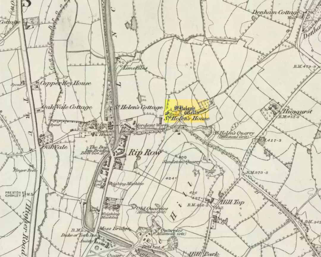
Highlighted on the very first OS-map of the region in 1848, this was one of many examples of a site dedicated to an important pre-christian deity which was eventually morphed into the character of Saint Helen. Several sites nearby were all named after the saint, including the quarries, a cottage, house and the wells themselves.
When Henry Taylor (1906) came here, he wrote the following about this once important site:
“This celebrated well is situated in a wild, rugged and hilly part of the hundred, in the south of the parish of Brindle… The water, brilliantly clear and sparkling, bubbles up through white sand at the bottom of a stone-lined pit, about seven feet square and four feet deep. On the southerly side of this pit, a few feet from it, is another similar stone-lined pit of about the same size. An old inhabitant tells me that formerly both pits — now nearly empty — were filled to the brim; and this was clearly the case, as an open stone channel is in situ, provided to carry the overflow water from the southernmost pit, the water dropping from it down into the valley. These structures are clearly of considerable antiquity, but the stones are somewhat displaced through neglect. The water now comes underground, through a pipe, into a farmyard about one hundred yards south of the well in a splendid crystal stream. Drinking water appears to be scarce in this district, for we met carts full of barrels which were apparently being taken to the neighbouring villages for sale from this spring.”
Folklore
Local folk visited here and dropped crooked pins into the well in the hope of wishes and future blessings — one report saying such practices were done by local catholics!
References:
- Taylor, Henry, The Ancient Crosses and Holy Wells of Lancashire, Sherratt & Hughes: Manchester 1906.
© Paul Bennett, The Northern Antiquarian
St, Helen’s Well, Brindle, Lancashire (SD 591 238)
A footpath leads from Denham Hill down to the M 61 at Whittle Spinney. This path once led to St. Helen’s Well, a very ancient spring. The building of the M 61 in 1968 destroyed the well and associated buildings. In 2003 the well was commemorated by the erection of a Celtic cross in nearby Whittle Spinney. The well had its hereditary guardians, the Gerards of the Well, who lived at St. Helen’s House that contained a Catholic chapel.
‘Over against Swansey house, a little towards the hill, standeth an ancient fabric once the manor-house of Brindle (St. Helen’s House), where hath been a chapel belonging to the same, and a little above it a spring of very clear water, rushing straight upward into the midst of a fair fountain, walled square about in stone and flagged in the bottom, very transparent to be seen, and a strong stream issuing out of the same. This fountain is called St. Helen’s well, to which the vulgar neighbouring people of the Red Letter (Roman Catholics) do much resort with pretended devotion in each year upon St. Helen’s day, where and when out of a foolish ceremony they offer or throw into the well pins which there being left may be seen a long time after by any visitor of that fountain’; Kuerden in Baines’ History of Lancashire. (ed. 1836), iii, 497.
Saint Helen, known in Welsh tradition as Elen Luyddog (Helen the Warlike) was a late 4th century founder of churches in Wales and the North West who is remembered as a saint. Traditionally she is said to have been a daughter of the Romano-British ruler Octavius and the wife of Macsen or Magnus Clemens Maximus, Emperor in Britain, Gaul and Spain, where he died seeking imperial recognition in 388.
Elen was mother of five, including a boy named Cystennin (or Custennin or Constantine), but she lived about sixty years later than Helena of Constantinople, the mother of Constantine the Great with whom she has, in times past, been confused. Together with her sons, Cystennin and Peblig, she is said to have introduced into Wales and the North West the Celtic form of monasticism from Gaul. Saint Gregory of Tours and Sulpicius Severus records that Maximus and Elen met Saint Martin of Tours while they were in Gaul. Her feast day is May 22.
Elen’s story is told in The Dream of Macsen Wledig, one of the tales associated with the Mabinogion. Welsh mythology remembers her as the daughter of a chieftain of north Wales named Eudaf or Eudwy, who probably lived somewhere near the Roman base of Segontium, now Caernarfon. She is remembered for having Macsen build roads across her country so that the soldiers could more easily defend it from attackers, thus earning her the name Elen Luyddog (Elen of the Hosts). Since many characters in these tales are thought to be Christianized reflections of older deities, it has been suggested that Elen reflects (along with Rhiannon, etc.) a tradition of goddesses of sovereignty.
The depositing of silver pins into sacred springs has its origins in Indo-European Shamanism.
She is said to have ordered the making of Sarn Helen, the great Roman road running from Caernarfon to south Wales via Dolgellau, Pennal and Bremia (Llanddewi Brefi). Though this road bears her name it is considerably older than Elen’s accepted time period. Many other Roman roads in Wales bear her name (e.g. Llwybr Elen) and she is thus acknowledged as the patron saint of British road builders and the protectress of travellers.
MISTAKE the well stood at SD 587 224, the Celitic cross memorial stands at SD 585 225.
Drawings & photo’s of well in: Henry Taylor ‘THE ANCIENT CROSSES AND HOLY WELLS OF LANCASHIRE’ revised edition, 2007, Vol. VI LEYLAND HUNDRED, NW Catholic History Society. ISBN 0-9541667-7-9
Sorry about that – John