Stone Circle (destroyed?): OS Grid Reference – NN 95294 05196
Take the A823 road up from Gleneagles to Glendevon and at the top of the long hill, where the road starts to level out and slightly drop, where the two glens meet up, take the right turn (west) and park up by the cattle-grid. Walk back onto the A823 and walk about 200 yards south towards Glendevon, to the small copse of trees past the cottage. As you get to the trees, look by the fencing and you’ll see one archetypal rounded standing stone, with another one next to it. You’re here!
Archaeology & History

At long last my huge nose is twitching back to its authentic sniffing-out lost sites in the landscape. During a visit to the St. Mungo’s Well a few days ago, on the way back to the car I kept saying to my fellow antiquarian Paul Hornby that “there’s something missing round here.”
“Wotcha mean?” he said.
“Summat missing Paul. It feels there should be a four-poster or summat like that here — where the two glens meet up. I can smell it. Summat should be here, or was here in the past.”
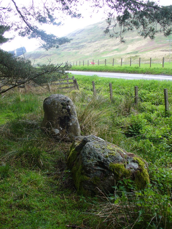
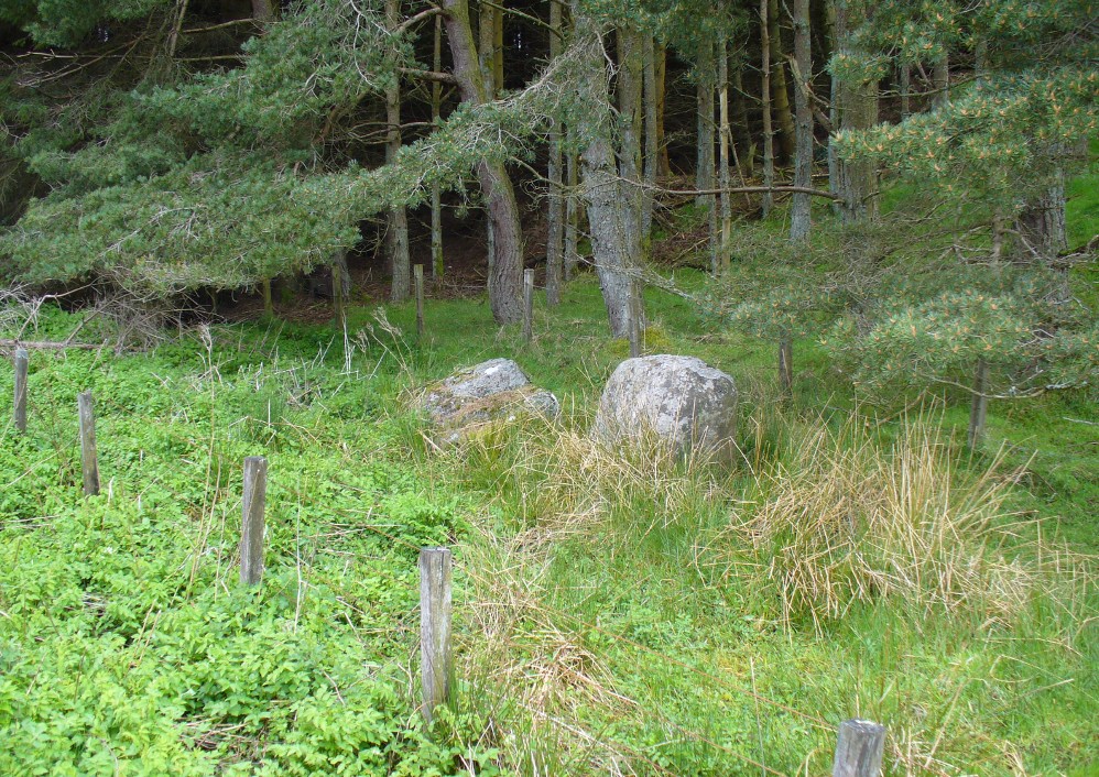
I said it several times as we walked back along the old track to the car. We took the photos and he set off to give me a grateful lift back home. But as we got back onto the road, we noticed a couple of upright stones just set back at the edge of a small copse of trees. One was very rounded and about four-feet tall, with a smaller companion next to it. But we didn’t stop to check them out as it was getting late.
A few days later Paul rang me to ask if I’d had a look at the old maps of the region where we’d visited and seen the old place-name where we’d been.
“No, why?”
“It’s known as the ‘Four Stanes’,” he said. “And right where those stones were standing by the trees!”
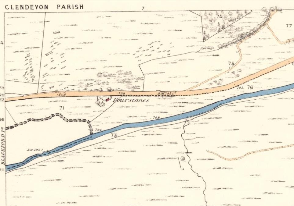
A few happy expletives came out, as usual for me. So I sought out the map he was talking about and, as we can see above, the “Fourstanes” (or Stones) are right where my ‘feelings’ and the stones were seen.
 On the 1860 Ordnance Survey map of the area, a small building is shown and named as ‘Fourstanes’ right by the roadside, on the south side. It was also named as such in an earlier account of 1851 and was told to be inhabited by a Mrs Foote in 1866. Sometime after this the cottage appears to have been left to neglect and no trace of it now remains. According to evidences of the place-name societies in England and Scotland and the studies of Smith (1956), Scott (2004) and others, unless the term derives from the Gaelic fuar, meaning cold or chilly, it is usually evidence of ‘four stones’ in relation to megalithic remains like those found from Shetland to the more southerly counties in England. Dr Aubrey Burl (1988) shows clearly in his textbook of the same name, that “four poster stone circles” are common megalithic architectural features in the Perthshire landscape — where this happens to be! He also states that such place-names should be listed and checked as possible “sites of destroyed four posters.” So we did just that!
Although the stones look very good contenders in the photos and also when you first see them close up, there are some elements here that need highlighting that throw a more sceptical view of them as authentic megaliths. The larger of the two stones—very rounded and worn, typical of other four-poster remains—is three feet high. The lichen vegetation covering it on all sides is old—except on its back (northern) upright face, where there is almost no vegetation at all. Indeed, this face is almost entirely clear of any natural plant growth, showing it was moved into this position from a lower horizontal level and pushed upright, I would say within the last century. The smaller, lower stone next to this upright oddity, is laid down and covered on all sides by an excess of vegetation expected of a monolith that has been in this position for several centuries at least. The lichen growth on this stone is very old.
Both of these stones occur along the line of an old wall and may have originally been a part of such a structure, instead of any four poster megalithic feature. However, the road that runs past here replaced the earlier track (which you can still walk along on the other side of the river 100 yards away) running through Glen Devon and into Glen Eagles. This “new road” as it was then, was made sometime in the 19th century. It may be that, upon the construction of the new road, the ‘fourstanes’ themselves were “in the way of Progress” (as they like to say) and so were rolled down the side of the new road and into the position they now occupy. It’s difficult to say.
There is one additional element that needs exploring. The hill immediately above Fourstanes is called ‘The Law.’ Although this word can be a simple “hill”, there are additional historical factors to a place-name. In Laurence Gomme’s (1880: 260-77) excellent work on the subject, he illustrates time and again across Scotland that heathen gatherings, tribal meetings and early court sessions or ‘moots’ were held at places with this place-name element. It should come as no surprise then, that at other megalithic sites in Britain called the Four Stones, ancient pagan moot were also held there. (Gomme 1880; Grinsell 1936, 1976)
We’re going back onto The Law itself in the next week or two, just to see if these ‘fourstanes’ are hiding away in the heather on the tops, where oh so many megalithic rings tend to be found….
…to be continued…
References:
- Burl, Aubrey, Four Posters: Bronze Age Stone Circles of Western Europe, BAR 195: Oxford 1988.
- Dwelly, Edward, The Illustrated Gaelic-English Dictionary, Gairm: Glasgow 1973.
- Gomme, Laurence, Primitive Folk Moots, Sampson Low: London 1880.
- Grinsell, Leslie V., The Ancient Burial Mounds of England, Methuen: London 1936.
- Grinsell, Leslie V., Folklore of Prehistoric Sites in Britain, David & Charles: London 1976.
- Scott, Margaret Rachel, The Germanic Toponymicon of Southern Scotland: Place-Name Elements, Glasgow University Press 2004.
- Smith, A.H., English Place-Name Elements – 2 volumes, Cambridge University Press 1956.
- Watson, Alexander, The Ochils – Placenames, History, Tradition, Perth & Kinross District Libraries 1995.
Acknowledgements: Huge thanks to Paul Hornby for considerable help in checking out the maps and helping in the rediscovery of this site.
© Paul Bennett, The Northern Antiquarian