Cairn: OS Grid Reference – NS 81244 99236
Also Known as:

Up, round the back of Stirling University, between Bridge of Allan to Greenloaning, take the steep zigzaggy Sheriffmuir Road uphill, until it levels out beyond the main wooded area where the hills open up on either side of you. There’s a little touristy parking spot further along the road, just below a small wooded bit. Keep going on the road for another ¾-mile, until you reach a small scattered copse of trees on your left. At the top of this copse, walk onto the moor on your left (west), following the old walling for more than another 500 yards, where a scatter of old trees live by the wallside. As this bends back downhill, note the rounded hill less than 100 yards above you (north). Go to the top of it!
Archaeology & History
There are several cairns hereabouts; yet despite several visits here, we still haven’t got round to checking them all out, as other little-known archaeological remains keep catching our attention (old walled structures and a possible enclosure). This is the most notable one of the bunch in the region — and easiest to find thanks to it being on top of the small hill where, many years ago indeed, was laid this small round rocky tomb of some long-dead chief, or granny, or someone!
There’s not been much written about this cairn, or its companions (Pendreich 2 & 3). It was referred to in the Scottish Royal Commission inventory for Stirlingshire (1963) where it’s listed as site no.3 as ‘Cairn, Sheriffmuir Road’, but their description is scant. They wrote:
“On a low ridge 800 yards WSW of spot-level 776 on the Sheriffmuir Road, and at a height of 800ft OD, there is a round cairn measuring 40ft in diameter and 2ft 8in maximum height. For the most part it is covered with grass, but a shallow depression in the centre, which may have been caused by excavation, reveals a few boulders.”

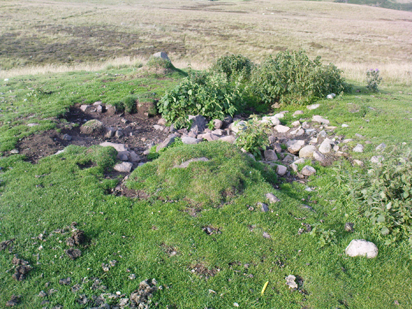
Indeed! This cut into the centre of the cairn is somewhat larger than the 1963 description implies, as one of the images here shows. But the grassy mound is pretty clear and there’s certainly something buried beneath here.
The views from here are excellent and gave the spirits the usual panoramic flights across the land, as at many other ancient tombs. The great pyramidal hill of Dumyat rises to the east; and just a few hundred yards away to the north, we find the long laid-out standing stone of Pendreich Muir, whose mythic history has all-but been forgotten…
References:
- Royal Commission on the Ancient & Historical Monuments Scotland, Stirling – volume 1, HMSO: Edinburgh 1963.
© Paul Bennett, The Northern Antiquarian