Settlement: OS grid reference – SE 1417 5199

Using the OS-map as a guide, from Denton village head up the road northwest, past Moorside Farm and onto the moor. Before you reach the rise of Lippersley Pike you’ll reach the Crow Well itself (completely covered over by Yorkshire Water’s handiwork, stopping anyone from drinking the previously fresh waters here). In the middle of nowhere, just above the completely ruined well, is the old shooter’s cottage and from here, Eric Cowling (1946) told us to look in the heather immediately east. When Richard Stroud and I ventured here a few years back (2.8.5) we couldn’t find a thing — though a vaguely reminiscent structure seemed possible 300 yards away.
Archaeology & History
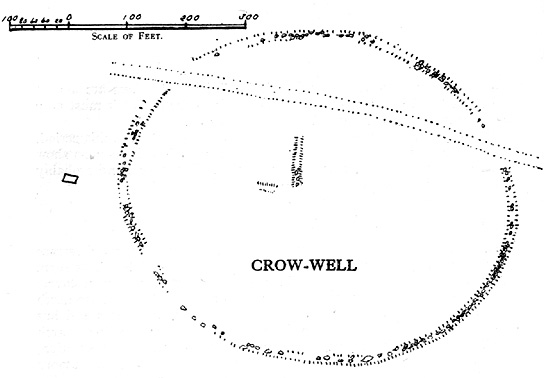
If the heather’s deep, you’ll have little chance of seeing the site as Eric Cowling (1946) obviously did! He described and illustrated this place — so was fortunate enough to have ventured here following the heather-burning.
The site is not a stone circle, but what Cowling thought to be an Iron Age settlement: ellipsoid in shape and nearly 400 feet across; it’s obviously an impressive archaeological site when visible (akin to the Snowden Carr settlement a couple of miles east). In all probability the site is much earlier than Iron Age.
An aerial image of the site indicates its size to be very close to Cowling’s initial measurements. The ‘settlement’ is quite huge, with the walling or defining edges being between 4 and 6 yards across in places, with double-walled sections akin to that found at the Brackenhall circle on Shipley Glen, just over 8 miles (13km) to the south. However, it’s probably much older than its Brackenhall compatriot. Its maximum diameters measure 130.5 yards (119.3m) roughly east-west and 98.5 yards (90m) roughly north-south, with an external circumference of about 345 yards (315m). This is a big fella! Near its centre is a well-defined ring, or ellipse, measuring approximately 20 yards (18.3m) north-south and 18 yards (17.5m) east-west.
It’s difficult to say what this might be without a site analysis, and we need the heather burning back at this site to enable a good inspection of the place! We may be looking at Denton Moor’s equivalent of the Woofa Bank Enclosure just over 4 miles (6.5km) to the south, above Ilkley, with its host of cup-and-rings and surrounding cairns. A good inspection of this site is long long overdue…
Hereabouts Cowling also found other remains dating from the neolithic period, including walling, cairns, hut circles and cup-and-ring stones. He thought that “the name Crow-well appears to be the modern equivalent of ‘the circle of the well'” — and although I doubted this in my Old Stones of Elmet, I have since come to realise the truth of his words!
References:
- Bennett, Paul, The Old Stones of Elmet, Capall Bann: Milverton 2001.
- Cowling, Eric T., Rombald’s Way: A Prehistory of Mid-Wharfedale, William Walker: Otley 1946.
© Paul Bennett, The Northern Antiquarian